Preserving the quality of life in the Miracle Mile, Los Angeles
Miracle Mile Historical Photo Collection
View looking west at the intersection of Wilshire Boulevard and Cloverdale Avenue, circa 1939. The Sontag Drug Store is seen on the northwest corner. Today it is the location of Wilshire Beauty Supply. The sign for the A and P Food Palace can be seen, the grocery store was next-door to Sontag’s.
This collection of photos, vintage postcards and ephemera, offers a unique perspective of the rich history of the Miracle Mile [scroll down to view slide show].
Wonderful short documentary on the last elevator operator in the Miracle Mile
For the definitive history of the Miracle Mile read:
Miracle Mile in Los Angeles; History and Architecture
by Ruth Wallach
Available at Amazon.com
A Circa 1978 Commercial for Zachary All
[click on image to view]
Edward G. Nalbandian (1927–2006) was the owner of Zachary All Clothing, a store he opened in the 1950s at 5467 Wilshire Boulevard in the Miracle Mile.
Nalbandian became a minor celebrity, making frequent appearances in commercials for his store. Most of these commercials featured the line “Come on down to 5-4-6-7 Wilshire Boulevard.”
In one commercial, Nalbandian said of his low prices, “My friends all ask me, ‘Eddie, are you kidding?’ And I tell them no, my friend, I am not kidding.” This inspired the Frank Zappa song Eddie, Are You Kidding? from the album Just Another Band from L.A. (1972).
In later years Nalbandian’s son took over the store’s operation. 5467 Wilshire is now occupied by a Walgreen’s drug store.
These images may be subject to copyright; rights assessment is your responsibility.
Click on a photo to begin slideshow…
Wilshire Boulevard near what is now know as Fairfax Avenue, circa 1920. The posted speed limit is 20 mph. (Los Angeles Conservancy)
Aerial view of the Wilshire area. View shows Wilshire Boulevard at La Brea. Note oil well drilling rigs, left corner of this photo. Photograph dated 1922. (Security Pacific National Bank Collection; Los Angeles Public Library)
Cars travel in both directions on Wilshire Boulevard, as seen from east of La Brea Avenue. Small palm trees and billboards are seen on both sides of the boulevard. Photograph dated 1920. (Blackstock Negative Collection ; Los Angeles Public Library)
Aerial view, circa 1920, looking north along Fairfax Avenue at the intersection of Wilshire Boulevard. An aviation fair in underway at Chaplin Airfield. DeMille Airfield in located in the upper left corner. (USC Digital Library)
Aerial view of Chaplin/Rogers Airport, circa 1920. Wilshire Boulevard is the tree lined street; Fairfax runs from the left to upper right corner.
Aerial view of the intersection of Wilshire Boulevard and Fairfax Avenue, showing Rogers Airport, 1920. The towers of oil siphons fill the expanse of cleared land above the intersection of the two roads. A few striped display tents have been pitched in the clearing below them. There is a possibility that the road on the lower right corner is what eventually became Olympic. The diagonal dirt road above it is what became San Vicente blvd. The road that goes from left to right midway up the photo is Wilshire, and the one that intersects it Fairfax, which at that time may still have been called Crescent Avenue. (USC Digital Library.)
Aerial view of Carthay Center, looking west across field of the first Rogers Airport at Wilshire Boulevard and Fairfax Avenue. Wilshire Boulevard is the tree-lined street seen in the center of the image, 1922. (Los Angeles Public Library.)
Rogers Airport was created in 1919 as Chaplin Airfield; Emory Rogers purchased the business from Sydney Chaplin and renamed the airfleid. Photograph dated 1922. (USC Digital Library.)
Dirigible landing at Demille Field, circa 1919. (GeneralAviationNews.com)
Advertisement for the Syd Chaplin Aircraft Corporation featuring their schedule of flights, circa 1919. (Water and Power Associates)
Aerial view of La Brea tar pits and oil derricks, circa 1924. Seen from the air you have to look carefully at the foreground (across the road from the buildings) to see the pits among the trees, along with a building in the trees. A few pits can be seen in open area. At the top of the picture are a few of the derricks from the oil field. (Security Pacific National Bank Collection; Los Angeles Public Library)
La Brea Tar pits and the old Hancock Ranch House, circa 1910. In the distance to the left are the Hancock oil fields and the Hollywood Hills.
Several men excavate pleistocene animal remains at Rancho La Brea, circa 1911. In the distance is the Hancock Oil fields and the Hollywood Hills. (Security Pacific National Bank Collection; Los Angeles Public Library)
Elephant limb in tar pit ( E.S. Cobb, photographer), 1911. A worker removes the surface debris from an elephant limb bone found in one of the pits. The bones were first uncovered and then freed of their asphalt matrix by the use of small trowels. (Security Pacific National Bank Collection; Los Angeles Public Library)
Men cleaning bones from tar pit (E.S. Cobb, photographer), 1911. After the bones have been removed from the pit they are cleaned in order to removed excess oil and asphalt. To help in the cleaning they are immersed in hot kerosene. (Security Pacific National Bank Collection; Los Angeles Public Library)
Aerial view of La Brea Tar Pits in Hancock Park, circa 1924. Looking from north of 6th St with Curson on the east (top), Ogden on the west (bottom), and Wilshire diagonally disecting the upper portion of the photo.
Donahue-Handley Real Estate office, 322 South La Brea Avenue, 1925. Note that La Brea Avenue is a dirt road. (“Dick” Whittington Photography Collection, 1924-1987; USC Digital Library)
Donahue-Handley Real Estate office, 322 South La Brea Avenue, 1925 (enlargement of previous photograph). The chalkboard signs promise that they can deliver La Brea frontage and lots on Hauser Boulevard for $3000.
The Gilmore gas station on the northeast corner of Wilshire Boulevard and La Brea Avenue; photograph dated 1928. The gas station was demolished the following year to make way for the construction of the E. Clem Wilson Building. The brick-clad building facing La Brea Avenue in the left background housed an office and switching station for the Southern California Telephone Company, completed in 1925 to serve the city’s western neighborhoods. It was enlarged from three to five floors in 1942 and given a complementary Art Deco facade by architects John and Donald Parkinson. It continues to operate today under the ownership of AT&T. (“Dick” Whittington Photography Collection, 1924-1987; USC Digital Library)
Another view of the Gilmore gas station at Wilshire and La Brea, circa 1928. The gas station was demolished in 1929 to make way for the construction of the E. Clem Wilson Building.
Intersection of Wilshire Boulevard and La Brea Avenue, 1928. Looking east along Wilshire. Note the Gilmore gas station on the northeast corner of Wilshire and La Brea; the following year it would be demolished to make way for the E. Clem Wilson Building. The white building at upper left is the Dyas-Carleton Cafe, built in 1925. The Bank of Italy (sign upper right corner) would become the Bank of America. (Los Angele Public Library)
The Fox Ritz Theatre, 5214 Wilshire Boulevard (on the southeast corner of Wilshire and La Brea), circa 1931. Designed by architect Lewis A. Smith, the 1600-seat Fox Ritz opened in 1926. It was demolished in 1977. (Los Angeles Public Library.)
Built as the Ritz Theatre in 1926, it joined the Fox theatre chain soon thereafter. The theatre building was on the south side of Wilshire and occupied the block between La Brea and Sycamore; this photograph features the Sycamore corner.
Another view of the Fox Ritz Theatre, circa 1932. (Los Angeles Public Library.)
Southeast corner of Wilshire and La Brea, showing the Ritz Theatre (left), Pardee Drug Co. building with a Security Trust & Savings Bank sign on top; circa 1947. (Security Pacific National Bank Collection; Los Angeles Public Library)
Fox Ritz Theatre lobby, 1942. View of the lobby and grand stairway of the Ritz Theatre. On the left is a stand for purchasing U.S. Defense Bonds and Stamps. (Security Pacific National Bank Collection; Los Angeles Public Library)
Fox Ritz Theatre proscenium, 1937. View of the elaborate proscenium and stage curtain. (Security Pacific National Bank Collection; Los Angeles Public Library)
Fox Ritz Theatre auditorium, 1937. (Security Pacific National Bank Collection; Los Angeles Public Library)
Fox Ritz Theatre auditorium balcony, 1942. Interior side wall of the auditorium, looking across balcony seating from the upper middle of the balcony. (Security Pacific National Bank Collection; Los Angeles Public Library)
Fox Ritz Theare on the south side of Wilshire just east of La Brea Ave. The original facade was “updated” following World War II.
Fox Ritz Theatre, circa 1955. According to IMDB, “White Feather” (1955) is the story of the peace mission from the US cavalry to the Cheyenne Indians in Wyoming during the 1870s. The mission is threatened when a civilian surveyor befriends the chief’s son and falls for the chief’s daughter.
Looking west along Wilshire Boulevard at La Brea Avenue, circa 1929. The Ritz Theatre is on the left; on the right the Security First National Bank (the first Art Deco structure on the Miracle Mile) is under construction. (Security Pacific National Bank Collection; Los Angeles Public Library)
Building site of Security First National Bank, photograph dated March 30, 1929. (California State Library)
Security First National Bank, 5207-5209 Wilshire Boulevard, nearing the completion of construction, 1929. (California State Library.)
The Security First National Bank later became known as the Security Pacific National Bank; photogragh circa 1938. (Top: “Dick” Whittington Photography Collection, 1924-1987; USC Digital Collection – Bottom: Justin Fields)
Security Pacific Bank, circa 1938/Art Deco Building, 2013. Top photo: The Security First National Bank later became known as the Security Pacific National Bank; photogragh circa 1938. (“Dick” Whittington Photography Collection, 1924-1987; USC Digital Collection.)
Security Trust and Savings Bank consolidated 1929 with Los Angeles First National Trust and Savings Bank, the new bank was known as Security-First National Bank of Los Angeles. Their Miracle Mile branch is denoted by the red star on the map. (Huntington Digital Library)
Detail of window on south facace, Security First National Bank, circa 1972. (Library of Congress)
Security First National Bank building, 5207-5209 Wilshire Boulevard, circa 1970s. (Library of Congress)
Storefronts located in the 5200 block of Wilshire Boulevard, just west of S. Sycamore Avenue. The Art Deco office building (left), which was once occupied by Security Pacific National Bank, is a Los Angeles Historic-Cultural Monument designed by Morgan, Walls & Clements, but the Spanish style building containing the Monaco Beauty Salon and A. Q. Fine Tailoring was later demolished and replaced with a fast food restaurant. (Marlene Laskey Collection; Los Angeles Public Library)
Exterior view of three storefronts located in the 5200 block of Wilshire Boulevard, just west of S. Sycamore Avenue (right). This entire Spanish style commercial building was later demolished and replaced with a fast food restaurant. Parked Cadillacs and Lou Ehler’s Cadillac dealership showroom, also demolished, are partially visible on the far right. (Marlene Laskey Collection; Los Angeles Public Library)
Miracle Mile, circa 1929. Looking east along Wilshire Boulevard. The prominent brick structure (center; left) is the telephone switching center still is existence on La Brea Avenue just north of Wilshire. (Library of Congress)
View of Wilshire Boulevard looking east, circa 1930. The E. Clem Wilson Building at the northeast corner of Wilshire and La Brea is under construction.
Exterior view, as illustrated in an architectural drawing, of the E. Clem Wilson Building in July 1930, located at the northeast corner of La Brea and Wilshire. (Ralph Morris Collection; Los Angeles Public Library)
Photograph of a view of Wilshire Boulevard seen from Detroit Street, May 1932. (California Historical Society Collection, 1860-1960: USC Digital Library)
Traffic at the intersection of La Brea Avenue and Wilshire Boulevard. The E. Clem Wilson Building was built in 1929. Architects: Meyer & Holler. The building was in Art Deco (Zigzag) Moderne style. The Wilson building was used as the exterior of the Daily Planet building in the first season of “The Adventures of Superman” television series. Photograph circa 1935. (Security Pacific National Bank Collection; Los Angeles Public Library.)
The E. Clem Wilson Building on the northeast corner of La Brea and Wilshire. The white structure in the lower lefthand corner is McDonnell’s Wilshire Cafe, formerly the Dyas-Carleton Cafe (the name that is still painted on the back wall of the restaurant). (Ralph Morris Collection; Los Angeles Public Library)
E. Clem Wilson Building, circa 1930. An Owl Drug Store operates on the street level. [Seaver Center Collection; Los Angeles Museum of Natural History]
Street level view of the E. Clem Wilson Building on the northeast corner of Wilshire at La Brea. Photograph circa 1951. (Dick Whittington Studio; Los Angeles Public Library)
The E. Clem Wilson Building located at 5217 Wilshire Boulevard, was designed by Meyer & Holler and built in 1930; it is a Los Angeles Historic-Cultural Monument. (Top: Ralph Morris Collection; Los Angeles Public Library – Bottom: Justin Fields)
A Simon’s drive-in restaurant, located at 5171 Wilshire Boulevard, with a sign for Halsco out front on the lawn. Nearby are a sign which encourages passers-by to “Read Examiner Want Ads,” a small Spanish-style commercial building (center, later demolished), the offices for Mutual of Omaha in the E. Clem Wilson Building (upper left, later Samsung), located at 5217 Wilshire Boulevard, and two Wilshire Lanterns (left). Herman J. Schultheis Collection. (Los Angeles Public Library)
The E. Clem Wilson Building at the intersection of Wilshire and La Brea, circa 1930.
E. Clem Wilson Building, circa 1935 & 2013. Left photo: The E. Clem Wilson Building was built in 1929. Architects: Meyer & Holler. The building was in Art Deco (Zigzag) Moderne style. Photograph circa 1935. (Security Pacific National Bank Collection; Los Angeles Public Library.)
E. Clem Wilson building entrance, 5217 Wilshire Boulevard, circa 1930. (Mott-Merge Collection; California State Library)
The E. Clem Wilson Building at the northeast corner of Wilshire Boulevard and La Brea Avenue, circa 1970s. The Carnation Building can be seen in the distance.
Looking east down Wilshire Boulevard, showing the offices for Mutual of Omaha (left) and the Carnation Company Building behind it. The Mutual of Omaha tower was added to the E. Clem Wilson Building, an Art Deco style office tower built in 1929. Architects: Meyer & Holler. (LaBonge Collection; Los Angeles Public Library)
Looking east on Wilshire at the E. Clem Wilson building at La Brea and Wilshire, 1954.
Looking east along Wilshire Boulevard @ Cloverdale, 1954 & 2013.
Contemporary view of the E. Clem Wilson buiding at Wilshire and La Brea.
The Dyas-Carleton Café, circa 1925. The restaurant featured a large dining room accommodating 250 patrons and an adjoining coffee shop with booths and a U-shaped counter. It was designed by the architect team of George Elmore Gable and C. Stanley Wyant, who were well known for their work in the Spanish Colonial Revival style. In 1929 they designed Hanger No. 1, the first structure built at Mines Field airport – now known as LAX.
Interior Dyas-Carlton Cafe, 1928. Built in 1925, the Dyas-Carlton Cafe was located on the northwest corner of Wilshire and La Brea. Designed in a Spanish architectural style by architects and builders Gable and Wyant, the restaurant seated 250 people. Photo dated: Mar. 31, 1928. (Herald-Examiner Colleciton; Los Angeles Public Library)
Exterior view of McDonnell’s Wilshire Cafe on the northwest corner of Wilshire and La Brea. The E. Clem Wilson Building is present in the background. McDonnell’s, a local chain of popular drive-ins and restaurants, took possession of the former Dyas-Carleton Cafe around 1931 and opened “McDonnell’s Wilshire Café”. It appears that the restaurant ceased operation at this location sometime after World War II.(Security Pacific National Bank Collection; Los Angeles Public Library)
McDonnells’s Wilshire Cafe, circa 1931, at the northwest corner of Wilshire and La Brea.
Looking southwest down La Brea Avenue from outside of Cedric’s Flower Shop, located at 677 S. La Brea Avenue at Wilshire Boulevard (far left, center). Numerous pots of poinsettias are visible in the street. McDonnell’s Wilshire Cafe was located on the south side of the flower shop. (Herman J. Schultheis Collection; Los Angeles Public Library)
Looking west along Wilshire Boulevard from La Brea Avenue, 1937. (Herman Schultheis Collection, Los Angeles Public Library.)
View to the northwest from the E. Clem Wilson Building at La Brea Avenue and Wilshire Boulevard, circa 1930. The commercial buildings in the foreground are on the west side of La Brea. The Detroit Arms apartment building is in the lower left corner. Photograph circa 1930s. (Hernam Schultheis Collection; Los Angeles Public Library)
Looking east along Wilshire Boulevard with the E. Clem Wilson Building at La Brea and Wilshire in the background. The Dominguez-Wilshire building is on the right. Sontag Drug Store is on the left. Photograph circa 1940. (USC Digital Library)
Auto Show in Hancock Park on Wilshire Boulevard at Stanley Avenue, 1935.
Wilshire Boulevard at Stanley Avenue, circa 1929. Looking east along Wilshire. (USC Digital Library.)
Enlargement of previous image. Wilshire Boulevard near Stanley Avenue, circa 1929.
Close-up of one of the many “Wilshire Special” streetlights that were prevalent along Wilshire Boulevard during the late 1920s and 1930s. The lamp post sits in front of the Van-Shire Florist open-air shop. To the left of the entrance, a young girl and woman look at the arrangements. Bilboards on either side of the shope advertise Union 76 gasoline and Southern Pacific railroad. The sign reads “Ride cool trains! $6 to San Francisco. $17 to Portland”. (Courtesy Water and Power Associates)
View of an oil field at the northeast corner of Wilshire and Curson. Photograph 1930. (Security Pacific National Bank Collection; Los Angeles Public Library.)
A view of Wilshire Boulevard looking west across Masselin Avenue. Notice the ornate lamp posts on each side of the street. The billboard on the right encourages businesses to locate in the Miracle Mile. (Los Angeles Public Library)
Postcard view (circa 1930) depicting Desmond’s original downtown store and their new branch at the Wilshire Tower, circa 1930s. Desmond’s was the first downtown department store to move to the Miracle MIle.
“‘Miracle Mile’s’ tower attracts — Wilshire Boulevard’s tower building continues to attract leading merchants. The latest lease taken in this ‘Miracle Mile’ building is by Silverwoods. The pioneer clothing firm will occupy the southeast corner, with a frontage of 60 feet. Twenty-year lease costs $500,000. — Firm leases new quarters — Coming as the second downtown merchant to locate in the ‘Miracle Mile’ on Wilshire boulevard in the last few months, announcement was made yesterday of the leasing of space in the Wilshire Tower Building by Silverwood’s. — Quarters to be occupied by the pioneer clothiers is located a the southeast corner of Wilshire boulevard and Burnside avenue, a few blocks west of La Brea avenue. It has a frontage of 60 feet and a depth of 125 feet, an includes the”… — Examiner clipping attached to verso, dated 11 May 1929. (Los Angeles Examiner Collection; USC Digital Library)
Looking south along an unpaved Burnside Avenue at the Wilshire Tower on Wilshire Blvd.
Wilshire Boulevard at Ridgeley Drive, 1929. The Desmond’s Building (also known as the Wilshire Tower) is on the right.
Wilshire Tower (aka Desmond’s Buiding) entrance, circa 1930. (Mott-Merge Collection; California State Library)
Closer look at Wilshire Tower entrance, circa 1930. (Mott-Merge Collection; California State Library)
Another view of the Wilshire Tower entrance, circa 1930. (Mott-Merge Collection; California State Library)
Wilshire Tower lobby-entryway looking toward parking entrance, circa 1930. (Mott-Merge Collection; California State Library)
Wilshire Tower elevator and directory, circa 1930. (Mott-Merge Collection; California State Library)
Wilsire Tower entryway and staircase, circa 1930. (Mott-Merge Collection; California State Library)
Wilshire Tower lobby-entryway ceiling detail, circa 1930. (Mott-Merge Collection; California State Library)
Display window, Wilshire Tower lobby, circa 1930. (Mott-Merge Collection; California State Library)
Interior Desmond’s department store, circa 1930. (Mott-Merge Collection; California State Library.)
Desmond’s building (aka Wilshire Tower), circa 1930s. (Mott-Merge Collection; California State Library.)
Desmond’s Building, circa 1937 & 2013. Top photo: Desmond’s building, circa 1937. (Top: Mott-Merge Collection; California State Library – Bottom: Justin Fields)
Desmond’s was the first major clothing retailer on the Miracle Mile. The stores opened in 1929.
Betty Alden Shoppe, Wilshire Tower, circa 1930. (California State Library)
A view of Silverwood’s in the Wilshire Tower (better known as the Desmond’s building). A large sign on top of the store displays “Silverwoods, Hart Schaffner & Marx, clothes”. The corner of the building is curved and has a large expanse of glass that covers two stories. A 20 mph speed limit sign is posted on a street light. Photograph dated: Jun. 24, 1936. (Los Angeles Public Library.)
Desmond’s Building 1936 & 2013. Top photo: A view of Silverwood’s in the Wilshire Tower (better known as the Desmond’s building). A large sign on top of the store displays “Silverwoods, Hart Schaffner & Marx, clothes”. The corner of the building is curved and has a large expanse of glass that covers two stories. A 20 mph speed limit sign is posted on a street light. Photo dated: Jun. 24, 1936. (Top: Los Angeles Public Library – Bottom: Justin Fields)
Combination of the Desmond’s building and Wilshire Boulevard, 1936 with a contemporary view by Justin Fields.
Silverwood’s store, circa 1930. The signage in the window promotes the opening of the new store. (Security Pacific National Bank Collection; Los Angeles Public Library)
Looking east at the Silverwood’s sign at night, circa 1930. Silvewood’s was located on the southeast corner of Wilshire Boulevard and Burnside in the Desmond’s building. (Courtesy of Water and Power Associates)
Nighttime view of the Silverwood’s display window on the west end of the Desmond’s building, circa 1940s.
A group of people walks across the street in front of the Desmond’s store window. A large Christmas tree with a star on top is on the sidewalk in front of them. Over the years stores such as Desmond’s and Silverwoods have occupied Wilshire Tower’s ground floor while professionals have leased offices in the eight-story tower. Located at 5514 Wilshire Boulevard, the Zig-Zag Moderne building was designed by architect Gilbert Stanley Underwood and built in 1928. This building was designated Los Angeles Historic-Cultural Monument #332 in 1987. Photograph circa 1939. (Herman J. Schultheis Collection; Los Angeles Public Library)
Entrance of the Wilshire Tower, the first Art Deco landmark tower built on Wilshire Boulevard. Over the years stores such as Desmond’s and Silverwoods have occupied the ground floor while professionals have leased offices in the eight-story tower. Located at 5514 Wilshire Boulevard, the Zig-Zag Moderne building was designed by architect Gilbert Stanley Underwood and built in 1928. Photograph dated 1978. (Marlene Laskey Collection; Los Angeles Public Library)
Contemporary view of the neon signs on the Desmond’s tower. The Desmond’s signs are featured on the north and south sides of the tower; the Silverwood’s signs are on the east and west sides. These are the only historic neon signs still in existence in the Miracle Mile.
Desmond’s Building (Wilshire Tower), circa 1940. [Seaver Center Collection; Los Angeles Museum of Natural History]
Ralphs arcade-style building on Wilshire and Hauser Blvd. in 1928. Small shops in the building include Dent Music Company and Tom Campbell Nuts. (Ralph Morris Collection; Los Angeles Public Library)
A Pig’n Whiste restaurant (see sign on roof) was located in the Ralph’s Market building from 1929 to 1938. The restaurant was closed when the Pig’n’Whistle company opened its new upscale restaurant, Melody Lane, at Detroit and Wilshire.
Ralph’s Market at Hauser and Wilshire Boulevards, circa 1930s. The Spanish Colonial Revival building with a sidewalk arcade was designed by Morgan, Walls and Clements and constructed in 1928. It was demolished in the early 1980s and replaced with a modern structure.
Ralph’s Grocery Store, circa 1930 & 2013. Top photo: Ralph’s Market at Hauser and Wilshire Boulevards, circa 1930. The Spanish Colonial Revival building with a sidewalk arcade was designed by Morgan, Walls and Clements and constructed in 1928. It was demolished in the early 1980s and replaced with a modern structure. (Bottom photograph by Justin Fields.)
Ralph’s Grocery Store building, circa 1950. It appears that people are lined up for a parade along Wilshire Boulevard. (eBay)
Ralphs ad, Van Nuys News, April 8, 1946. According to the ad, “Ralphs closed for three and a half years because of fire and reconstruction limitations…” During World War II building materials were rationed to support the war effort, hence the delay in rebulding the store.
Looking east along Wilshire at Hauser, circa 1935. Ralph’s Supermarket on the left; Coulter’s Department Store on the right. (“Dick” Whittington Photography Collection; USC Digital Library)
The Darkroom was a Miracle Mile camera store located at 5370 Wilshire Boulevard. The original building was constructed in 1926, but the “camera” storefront was built in 1938. It was designed by architect Marus Miller. Its black vitrolite glass façade is one of the most famous examples of roadside or programmatic architecture in the world – and one of the last remaining examples in Los Angeles. Its design has been replicated at Disney Studios Paris and Universal Studios Orlando. The store is now part of El Toro Cantina. The façade is protected as a Los Angeles Historic-Cultural Monument. (Marvin Rand, photographer; Library of Congress)
The Darkroom, circa 1975 & 2013. Left photo: The Dark Room, 5370 Wilshire Boulevard. Constructed in 1937 as the facade for a camera shop. Architect: Marcus P. Miller. Present location of El Toro Cantina. (Top: Marvin Rand, Photographer; Library of Congress – Bottom: Justin Fields)
Darkroom Camera Shop for lease, 1981. Two pedestrians pass the former camera store, The Darkroom, located at 5370 Wilshire Boulevard. The 1937 Art Deco building, designed by Marcus P. Miller, has been occupied by several businesses and restaurants since the camera shop closed. (Herald-Examiner Collection; Los Angeles Public Library)
Color view of The Darkroom, 1978. (Marlene Laskey Collection; Los Angeles Public Library)
Darkroom Camera Shop Sign, 1978. (Marlene Laskey Collection; Los Angeles Public Library)
Photograph of an architect’s drawing of a forty-story hotel to be built in Hancock Park district, Los Angeles. An Examiner clipping with no text attached to verso, dated, “November 29, 1929”; “Architect’s sketch of forty-story hotel to be built in Hancock Park district by A.W. Ross” — Examiner clipping attached to verso, dated, “December 21, 1929”. Additional information: this is a drawing of a design by the architect Kenneth MacDonald, Jr., for a hotel that the real estate developers of Miracle Mile, Charles E. Cooper and A. W. Ross, wanted to build on Wilshire Boulevard near Ogden Drive. Because Miracle Mile lay outside the city boundaries, the building would not have been subjected to the limit height ordinance. But it was never built. See “skyscraper hotel sketched” LAT, August 16, 1929. (Caption and image courtesy of USC Digital Library.)
Los Angeles Times advertisment dated March 29, 1935 announcing the opening of the A & P grocery store at Wilshire and Cochran.
The Atlantic and Pacific Food Palace on the north side of Wilshire Boulevard between Cochran and Cloverdale Avenues, circa 1937. It later became the Roman Food Market and the original structure is now incorporated into a Staples office supply store.
Atlantic and Pacific Food Palace, circa 1937 combined with the Staples Office Supplies, 2013. Top photo: The Atlantic and Pacific Food Palace on the north side of Wilshire Boulevard between Cochran and Cloverdale Avenues, circa 1937. It later became the Roman Food Market and the original structure is now incorporated into a Staples office supply store. (Bottom photograph by Justin Fields.)
The Atlantic and Pacific Food Palace at 5413 Wilshire Boulevard; photograph dated 1935. (Dick Whittington Studio; USC Digital Library)
Looking northeast across Wilshire Boulevard towards two commercial buildings; the storefront on the right, located at 5403 Wilshire Boulevard, is shown when it was occupied by a copy center. Roman Foods Market (left), located at 5407 Wilshire Boulevard, later became a Staples office supply store. (Marlene Laskey Collection; Los Angeles Public Library)
Roman Market, circa 1978. (Marlene Laskey Collection; Los Angeles Public Library)
Wimpy Grill (located at 5425 Wilshire Boulevard, later the Flying Saucer restaurant) and the adjacent shops (later Brown’s Wilshire Bakery) were remodeled to create one large commercial space to accommodate a Staples office supply store. Photograph circa 1938. (Herman J. Schultheis Collection; Los Angeles Public Library)
Interior view of the Wimpy Grill, circa 1937, Later known as the Flying Saucer. (Herman J. Schultheis Collection; Los Angeles Public Library)
Around 1939 – when the “Wizard of Oz” was made – Judy Garland and her mother, Ethel Gumm, opened a flower shop in the Miracle Mile at 5421 Wilshire Blvd. It was later the location of Brown’s Bakery. The building was demolished in the 1980s and is now where the Staples office supplies store is located. It appears that Miss Garland’s foray into the florist business was shortlived. (WPA Collection; Los Angeles Public Library)
A publicity shot of Judy
Garland in her flower shop in the Miracle Mile, circa 1939.
Looking north across Wilshire Boulevard towards three businesses, the Flying Saucer restaurant (left), Brown’s Wilshire Bakery (former location of Judy Garland’s flower shop), and the Roman Foods Market (right). In the late 1980s the Flying Saucer – formely Wimpy’s – and Brown’s were demolished and a new building was constructed to include the Roman Foods structure as a Staples office supply store. (Marlene Laskey Collection, Los Angeles Public Library)
Flying Sauce Restaurant and Brown’s Bakery, 1978/Staples Office Supplies, 2013. Top photo: Looking north across Wilshire Boulevard towards three businesses, the Flying Saucer restaurant (left), Brown’s Wilshire Bakery, and the Roman Foods Market (right); photograph dated 1978. In the late 1980s the Flying Saucer – formely Wimpy’s – and Brown’s were demolished and a new building was constructed to include the Roman Foods structure as a Staples office supply store. (Top: Marlene Laskey Collection, Los Angeles Public Library – Bottom: Justin Fields)
Close-up exterior view of the Flying Saucer barbecue restaurant, located at 5425 Wilshire Boulevard, showing the neon signs above the entrance. (Marlene Laskey Collection; Los Angeles Public Library)
Close-up exterior view of Brown’s Wilshire Bakery (1978), located at 5423 Wilshire Boulevard, showing the neon sign above the entrance. Years later, this French style storefront, the Flying Saucer restaurant to the west, and the Roman Foods Market to the east were remodeled to create one large commercial space to accommodate a Staples office supply store. (Caption and image courtesy of the Marlene Laskey Collection, Los Angeles Public Library)
Wilshire Boulevard., circa 1932. View from the E. Clem Wilson Building at Wilshire and La Brea, looking west along Wilshire Boulevard, circa 1932. Myer Siegel Department Store occupied the two-floors at the base of the Dominguez Building at 5400 Wilshire. In the distance is the Wilshire Tower, also known as the Desmond’s building – so named for Desmond’s, the first department store to locate in the Miracle Mile.
Designed by Stiles O. Clements, this classic Streamline Moderne building was built in 1938 by Coulter’s Dry Goods. The store changed hands in the 1970s and became the Broadway Department Store. After the building was demolished in 1980 the site remained vacant until the late-2000s, when a 5-story mixed-use structure was built. It is the most significant art deco structure ever to be demolished in the Miracle Mile
Coulter’s Department Store, circa 1938. View looking west on Wilshire Boulevard. The Coulter Building is seen on the northeast corner of Hauser and Wilshire. This building was built in 1938 and designed by architect Stiles O. Clements. Citizens National Trust & Savings Bank may also be seen on the right. (Security Pacific National Bank Collection; Los Angeles Public Library.)
Coulter’s Department Store, circa 1938. This view looking southwest at Wilshire and Hauser boulevards includes the Coulter’s department store. (Herman J. Schultheis Collection; Los Angeles Public Library)
Coulter’s Department Store, circa 1950. (Noirish Los Angeles; Skyscraperpage.com)
View along Wilshire of Coulter’s Department Store, circa 1938. The partially obscured billboard on the right promotes A. W. Ross’ real estate company. Ross is the developer who created the Miracle Mile. (Herman J. Schultheis Collection; Los Angeles Public Library)
Coulter’s Wilshire entrance, circa 1950. (Noirish Los Angeles; Skyscraperpage.com)
Coulter’s department store display window, photograph dated October 7, 1948. The display celebrates “10 Years of Progress on Miracle.” (eBay)
Coulter’s interior with display cases, circa 1950. (Noirish Los Angeles; Skyscraperpage.com)
View of the interior of Coulter’s Department Store, the ladies undergarments department, with open merchandising spaces punctuated by columns, service areas along the perimeter and horizontal cabinets with rounded corners. Girdles are displayed on the cabinets along with flower bouquets and svelte statuettes. Staff, dressed in black and wearing corsages, pose behind the service counters. Designed by Stiles O. Clements, this classic Streamline Moderne building was first occupied in 1938 by Coulter’s Dry Goods. In the 1970s, the store changed hands and became a Broadway. After the building was demolished in 1980, the site remained vacant until the late-2000s, when a 5-story mixed-use structure was built. (Security Pacific National Bank Collection; Los Angeles Public Library)
Coulter’s Department Store fabric department display, circa 1948. (eBay)
Coulter’s fabric and sewing notions department, circa 1948. Talon brand zippers are arranged in a display case with skeins of yarn displayed in the background. (eBay)
Coulter’s children’s shoe department, circa 1950. (Noirish Los Angeles; Skyscraperpage.com)
Undated photograph of Coulter’s fur salon.
Couler’s parking lot billboard sign, circa 1950, (Noirish Los Angeles; Skyscraperpage.com)
Another view of Coulter’s parking lot billboard sign, circa 1950. (Noirish Los Angeles; Skyscraperpage.com)
Facing west on Wilshire Boulevard at Hauser Boulevard. Western Auto Supply Company, Ralph’s Supermarket, and Bank of America (left); Coulter’s Department Store (right). Photograph circa 1938. (Dick Whittington Studios; USC Digital Library)
Coulter’s Department Store on left; the original Ralph’s supermarket on right.
Linen finish postcard of Wilshire Boulevard looking east, circa 1950s. Note the Orbach’s sign on left. Orbach’s was originally located in the Prudential Square complex. The block housing the California Federal Bank building later became the site of the “Cal Fed” skyscraper.
Coulter’s advertisement, circa 1939.
The Broadway (originally Coulter’s) Department Store, 5600 Wilshire Boulevard. By the time of this photograph (circa 1970s) the original facade of the streamline moderne structure had been obliterated in a misguided attempt to “update” the building. (Library of Congress; Call Number: HABS CAL,19-LOSAN,32–1)
The Broadway Department Store (formerly Coulter’s), circa 1970. In the right foreground is DuPar’s restaurant at Wishire and Ridgeley.
Rear of Broadway Department Store (formerly Coulter’s), circa 1970. All of the major department stores in the Miracle Mile featured large parking lots at the rear of the buildings.
Broadway Department Store on Wilshire Boulevard, 1978. Looking southeast from across Wilshire Boulevard towards the Broadway store. Located at 5600 Wilshire Boulevard and designed by Stiles O. Clements, this classic Streamline Moderne building was first occupied in 1938 by Coulter’s Dry Goods. In the 1970s, the store changed hands and became a Broadway. After the building was demolished in 1980, the site remained vacant until the late-2000s, when a 5-story mixed-use structure was built. (Marlene Laskey Collection; Los Angeles Public Library)
The Broadway Department Store (formerly Coulter’s), Wishire Blvd, 1972. The California Federal Bank Building is on the right – designed by Charles Luckman, it was constructed in 1963. (Library of Congress; Call Number: HABS CAL,19-LOSAN,32–2)
After the former Coulter’s was demolished in 1980 the site remained vacant for 20 years. It became known in the neighborhood as “the pit.”
Aerial view looking west from Wilshire and Sycamore, circa 1930. The oil field on the upper right is where the Park La Brea apartments complex is now located.
Wilshire Boulevard between Cloverdale Avenue and Cochran Avenue, circa 1920s. The Dominguez Wilshire was constructed on this site in 1930. (Dick Whittington Studio; USC Digital Library)
The Dominguez Wilshire Building at 5410 Wilshire under construction; photograph dated 1930. Designed by architects Morgan, Walls, and Clements. (California State Universtiry Dominguez Hills Digital Collections.)
The Dominguez-Wilshire building under construction, 1930. (CSUDH Digital Collections)
Another view of the Dominguez-Wilshire building under construction.. A sign on the fence identifies the contractor as the C. L. Peck Company. (CSUDH Digital Collections)
Dominguez Wilshire Building, circa 1955. (Californina State University Dominguez Hills Digital Collections.)
The Dominguez Wilshire Building shortly after opening; photograph dated 1931. Signs on the street level facade identify the leasing agent as A. W. Ross (the creator of the Miracle Mile). The signs also tout that the building is 75% rented. (Los Angeles Examiner Collection, 1920-1961; USC Digital Library)
“Dominguez Building in ‘Miracle Mile’ sector of Wilshire Boulevard, leased to 75% of its capacity before completed. It was designed by Morgan, Walls & Clements, architects of this city.” — Examiner clipping attached to verso, dated 7 February 1931. (Los Angeles Examiner Collection; USC Digital Library)
Interior view of Myer Siegel and Company store, circa 1933. Myer Siegel was a high-end women’s clothing store located in the Dominguez Wilshire Building. (Mott-Merge Collection; California State Library)
View from across Cloverdale Avenue of the rear of the Dominguez Wilshire building, circa 1931. (Mott-Merge Collection; California State Library)
Dominguez Wilshire building lobby, circa 1931. (Mott-Merge Collection; California State Library)
Dominguez Wilshire Building entrance, 5410 Wilshire Boulevard, circa 1931. (Mott-Merge Collection; California State Library)
Contemporary photograph (circa 2005) of the Wilshire Bouevard entrance of the Dominguez Wilshire Building. (wikimapia.org)
Dominguez Wilshire Building, 5410 Wilshire Blvd., 1958. “12-story building brings ‘over million’ — Dr. Hiss buys edifice at 5410 Wilshire Boulevard.” — Examiner clipping attached to verso, dated 5 January 1958. (Los Angeles Examiner Collection, 1920-1961; USC Digital Library)
Dr. Hiss Shoe Stores ad, Long Beach Independent, June 30, 1960. In 1958 the Dominguez Wilshire building was purchased by Doctor Hiss, a foot doctor, and renamed the Hiss Tower.
Dominguez-Wilshire Building, 5400-5420 Wilshire Boulevard. This building represents a classic Moderne type of the 1920s and 1930s. A central tower is presented as an attenuated vertical block where the scale is deceptively presented so that one is not aware of its actual height. The tower is held in place by two-story wings to each side; zigzag (Art Deco) relief ornament. Photograph circa 1970. (Library of Congress; Call Number: HABS CAL,19-LOSAN,39–1)
Dominguez-Wilshire Building, circa 1933 and 2013. The building opened in 1931 with retailer Myer Siegel as the major tenant. (Bottom photograph: Justin Fields.)
Wilshire Boulevard looking east from Dunsmuir Avenue. The Dominguez Wilshire building on the right; the White Spot, a popular restaurant and cocktail lounge, on the left. (Dick Whittington Photography Collection, 1924-1987; USC Digital Library)
Color photograph of the Dominguez Wilshire Building, circa 1957. (Rancho San Pedro Collection; California State University Dominguez Hills Digital Collections)
Linen-finish postcard looking west along Wilshire Boulevard featuring the Dominguez Wilshire Building on left, circa 1940s. (Dick Whittington Studio)
“Greetings from California” postcard, circa 1945.
Miracle Mile postcard, circa 1948. Looking east down Wilshire from Burnside Avenue featuring the El Rey Theatre and E. Clem Wilson Building on the north (left) side of the street and Desmonds Department Store and Wilshire-Dominguez building on the south side. Kodachrome postard, circa 1948. (CSUDH Digital Collections)
Contemporary view of the rear of Dominguez-Wilshire Building. An apartment building is planned to built on the land occupied by the parking lot on southside of the building.
Aerial POV of Wilshire Blvd, 1983, Looking west down Wilshire Boulevard from Cloverdale Avenue. Several landmark buildings are visible on both sides of the street. (William Reagh, photographer; Los Angeles Public Library)
Looking west along Wilshire toward the Dominguez-Wilshire building (on left) at the intersection of Cloverdale.
Looking southeast from across Wilshire Boulevard and South Dunsmuir Avenue towards an Italian style commercial building, located at 5478 Wilshire Boulevard. (Marlene Laskey Collection; Los Angeles Public Library)
The Woolworth store under construction at 5460 Wilshire Boulevard under construction, circa 1932. (CSUDH Digital Collections)
The Western Auto Supply store at the northwest corner of Wilshire and Hauser, circa 1930s. Designed by Carl Lindbom and completed in 1931, it is the current location of a IHOP restaurant.
Best Western Auto Supplies, circa 1931/IHOP, 2013. Top photo: The Western Auto Parts store at the northwest corner of Wilshire and Hauser, circa 1931. Designed by Carl Lindbom and completed in 1931, it is the current location of a IHOP restaurant. (Bottom photograph: Justin Fields.)
Western Auto Supply Co. display window, circa 1933. (Mott-Merge Collection; California State Library)
Another view of the Western Auto Supply, circa 1930. (Los Angeles Conservancy)
View of the northwest corner of Wilshire and Hauser showing the Western Auto Supply Co. Building. Several cars are seen parked on Hauser Blvd.; circa 1930s. (Water and Power Associates)
Shanghai Winter Garden, 1978. Looking northwest across Wilshire Boulevard towards the Shanghai Winter Garden Chinese restaurant, 1978. Located at 5651 Wilshire Boulevard at the corner with Hauser Boulevard, this eatery later became an International House of Pancakes (IHOP) restaurant. (Marlene Laskey Collection; Los Angeles Public Library)
Simon’s Drive In Cafe at the northwest corner of Fairfax and Wilshire; photograph dated 1938. The following year construction would begin on the May Company on the lot with the billboard. In 2014 work is scheduled to begin converting the former May Company building into the Academy Museum. (“Dick” Whittington Photography Collection, 1924-1987; USC Digital Collection)
Looking northeast across Wilshire Boulevard and Fairfax Avenue at the May Company under contruction, circa 1939. Architects: Albert C. Martin & S.A. Marx. The building was purchased by the Los Angeles County Museum of Art in 1994. (Dick Whittington Studio; USC Digital Library)
View looking across Fairfax Avenue toward the northeast corner of Fairfax and Wilshire showing cranes and scaffolding surrounding the May Company store under construction, 1939. (Water and Power Associates)
Northern facade of the original May Company building, 1941. In 1946 a new addition was constructed on this side of the building.
The original May Company building in 1941. In 1946 the building was expanded on its northern side.
May Company, circa 1947 & 2013. Architects: Albert C. Martin & S.A. Marx. Constructed in 1939, the building was purchased by the Los Angeles County Museum of Art in 1994. It will be the future home of the Academy Museum. (Bottom photograph: Justin Fields)
View of Fairfax Avenue side of the May Company, circa 1940s. (Huntington Library Digital Library)
May Company , circa 1940 & 2013. Top photo: View of Fairfax Avenue side of the May Company, circa 1940. The original building opened in 1939. The store was expanded to the north in 1946. It is this addition that will be razed for the construction of the new Academy Museum. (Bottom photograph: Justin Fields)
Another view of the May Company at Wilshire and Fairfax, circa 1950s. (Dick Whittington Studios; USC Digital Library)
Aerial view showing the May Company department store shortly after its opening in 1940. To the left of it in this photo, we can see the popular Simon’s Drive-in restaurant where the Googie-influenced Johnie’s Coffee Shop now stands. (Water and Power Associates.)
Aerial view of original May Company building and gas station, 1940. The view is from the west of Orange Grove Drive of the original May Company building and gas station (at 6th Street and Fairfax Avenue).
The intersection of South Odgen Drive and Wilshire Boulevard with the May Company building and appliance store, 1963.
Christmas season view of the May Company Annex, circa 1940s. The annex fronted on Wilshire Boulevard, just east of the main store. It was demolished after the Los Angeles Museum of Art acquired the May Company property and is the present location of the Broad Contemporary Art Museum.
View looking southwest from the intersection of 6th Street and Ogden Drive showing the May Co. and its multi-story parking structure. (Photo by Julius Shulman via Getty Collection)
View is looking east from Fairfax towards the Miracle Mile section of Wilshire Boulevard, 1972. First building on the left is the May Co. building, designed by architect A.C. Martin, and built in 1939. Second building is the Los Angeles Museum of Art, designed by architects: Pereira & Assoc., and built in 1964. Third building is the Prudential Building (later Museum Square), designed by Wurdeman & Becket, and built in 1948. The California Federal Plaza Building is the tall building in the right background; in the right foreground is the Mutual Benefit Building at 5900 Wilshire Boulevard. (Los Angeles Public Library)
The May Company on the northeast corner of Wilshire and Fairfax, circa 1950s.
May Co. Wilshire store receipts, 1949. (eBay)
May Company at the intersection of Wilshire Boulevard and Fairfax Avenue, circa 1950,
The May Company Department Store Building, 6067 Wilshire Boulevard, circa 1970s. (Marvin Rand, photographer; Library of Congress)
Postcard of May Company at Wilshire and Fairfax, looking east along Wilshire Boulevard, 1947. (Pomona Public Library.)
Simon’s Drive-In Cafe, circa 1939. Located at the intersection of Wilshire and Fairfax, the restaurant was distinguished by the tall pylon emerging from the center of the round building. It was built in 1935 and designed by architect Wayne McAllister, who designed many drive-in restaurants. (Dick Whittington Studio, Huntington Digital Library.)
Another view of Simon’s Drive In Cafe showing a uniformed server, circa 1940s.
Back and front covers of a Simon’s Drive In restaurant menu; circa 1950s.
Another view of Simon’s Drive In Cafe; photogragh dated 1939. Note on the far left the May Co. gas station located on the southeast corner of Fairfax Avenue and 6th Street. (Automobile Club of Southern California collection, 1892-1963; USC Digital Library)
Night time view of Simons Drive-In Cafe, circa 1940s. Simon’s was on the northwest corner of Fairfax and Wilshire where Johnie’s Coffee Shop is now located.
The intersection of Fairfax Avenue and Wilshire Boulevard looking at Simon’s Drive In restaurant on the northwest corner; circa 1950s.
Gilmore gas station at the southwest corner of Fairfax Avenue and Wilshire Boulevard, circa 1930s. The building on the right (The Carthay Apartments) is still standing. The Gilmore family created the Farmers Market at Fairfax and Beverly.
Looking southeast down Wilshire Boulevard at San Diego Way (right, out of view). Various businesses, including the May Co. store at Wilshire and Fairfax (left), are seen on both sides of the boulevard; storefronts are being added onto the Carthay Building (center). The Foster and Kleiser billboard right of center is advertising Farmers and Merchants National Bank of Los Angeles. Photograph dated April 4, 1947. (Los Angeles Public Library)
Looking east from a neighboring parking lot towards the Carnation Company 9-story office building, which contains the company headquarters and a restaurant (lower center), located at 5045 Wilshire Boulevard. Photograph dated 1980. (Carol Westwood Collection; Los Angeles Public Library)
Looking northeast across Wilshire Boulevard, showing the headquarters and restaurant for the Carnation Company, as well as the headquarters for Imperial Savings & Loan Association (background, right). The 9-story Carnation Company Building, located at 5045 Wilshire Boulevard and built in 1949. In 1989 Carnation Company moved its headquarters to Glendale. The orginal building was extensively remodeled and doubled in size. (Marlene Laskey Collection; Los Angeles Public Library)
The Carnation restaurant is the single story structure at the base of the building.
Carnation Coffee Shop at 5075 Wilshire Blvd., circa 1949. (Maynard L. Parker, photographer; Huntington Library)
Former Carnation Building at 5055 Wilshire Boulevard. After the Carnation Company moved from this location in 1989, the original building (on right of entrance) was extensively remodeled and a matching addition was constructed (left of entrance).
Looking east down Wilshire Boulevard from just west of where it crosses Ogden Drive (center). Hancock Park is on the left, office buildings, including one for Financial Indemnity Company, are seen right of center and various billboards are seen on the right. Photograph dated January 2, 1959. (Courtesy the Los Angeles Public Library)
Looking northeast from across Wilshire Boulevard towards an Adray’s store and other businesses located at addresses ranging from 5557-5575. Years later, the storefronts on the right occupied by Barton’s Bonbonniere, Janet Shore Corsets, and Miracle Shoe Repair were remodeled to create one structure and replaced with a Smart and Final store. Adray’s later became a Rite Aid pharmacy. (Marlene Laskey Collection; Los Angeles Public Library)
View looking west at the intersection of Wilshire Boulevard and Cloverdale Avenue, circa 1939. The Sontag Drug Store is seen on the northwest corner. Today it is the location of Wilshire Beauty Supply. A sign for the A and P Food Palace can be seen, the grocery store was next-door to Sontag’s.
The Sontag Drug Store, located at the northwest corner of Wilshire Boulevard and Cloverdale Avenue, 1941. It was designed by Anderson and Norstrom in the Art Deco style and completed in 1935. (Photographer: Richard Stagg; USC Digital Library.)
Combination of the Sontag Drug Store image, circa 1941 and a contemporary view of Wilshire Beatuy Supply photographed by Justin Fields.
Sontag Drug Store, 1941/Wilshire Beauty Supply, 2013.
Top photo: The Sontag Drug Store, located at the northwest corner of Wilshire Boulevard and Cloverdale Avenue, 1941. It was designed by Anderson and Norstrom in the Art Deco style and completed in 1935. (Top: Richard Stagg; USC Digital Library – Bottom: Justin Fields)
A Sontag Drug Store matchbook cover, circa 1940s. Matchbooks were a popular means of promotion.
Sontag Drug Store employee nametag. (eBay)
Looking to the northwest; the vacant area in the upper righthand corner is now occupied by Park La Brea. Dick Whittington Studio, circa 1940.
A postcard view east along Wilshire Boulevard, circa 1947. The El Rey Theate is on the left, the Desmond’s Building is on the right. The El Rey Theatre is showing a double bill: “Mr. District Attorney” (1947) and “Strange Journey (1946). (Frasher Foto Postcard Collection, Pomona Public Library.)
A team of reindeer pulls a loaded sleigh across the sky in this night view of Wilshire Boulevard looking east at Burnside. A neon sign for the Bank of America is visible as well as the El Rey Theater on the far left, and the Wilshire Tower (Desmond’s building) on the right. Photogragh circa 1937, (Herman J. Schultheis Collection; Los Angeles Public Library)
Wilshire Tower (aka Desmond’ Building) decorated for Christmas, circa 1937. Designed by architect Gilbert Stanley Underwood and built in 1929, the Zig- Zag Moderne style Desmond’s/Wilshire Tower, which spans the addresses on Wilshire Boulevard from 5500-5522, and was declared City of Los Angeles Historic-Cultural Monument #332 in 1987. (Herman J. Schultheis Collection; Los Angeles Public Library)
The bus has stopped on Wilshire across from the original Ralph’s supermarket.
El Rey Theatre, 1937. According to Wikipedia, “Maid of Salem,” starring Claudette Colbert and Fred MacMurray, tells the story of a young girl in Salem, Massachusetts who has an affair with adventurer. She is sentenced as a witch, but saved by him.
Another view of the El Rey Theatre, circa 1937.
The El Rey Theatre, 5515 Wilshire Boulevard, circa 1987. Architect Clifford A. Balch designed this art deco gem. The theatre opened in 1937 and was designated a Los Angeles Historic-Cultural Monument in 1991. Since the early 1990s it has been a popular club with live concerts, including Bob Dylan and Elvis Costello.(William Reagh, photographer; California State Library)
Night view of the El Rey Theatre when it was a revival house, circa late 1970s. (Photograph by Tom Zimmerman)
Exterior view of the Art Deco El Rey Theatre, located at 5515 Wilshire Boulevard, 1989. (Photographer: Steve Grayson; Los Angeles Public Library)
Contemporay view of El Rey marquis. The El Rey is owned and managed by Golden Voice, a division of AEG Live.
Contemporary view of the El Rey Theatre. The popular music venue is managed by Golden Voice, a division of AEG.
Contemporary view of the El Rey Theatre ticket booth. (thenormaleye.com.)
Arthur Murray Dance Studio, 1944. Arthur Murray himself appeared at the 1941 opening of his “ultramodern” Los Angeles office and studio. The Late Moderne-style building by Stiles O. Clements prominently advertised the Murray studio with simple lettering on a freestanding wall that soared several stories above Wilshire Boulevard.
The front façade is nearly transparent above the ground story, a precursor to the floor-to-ceiling glass curtain walls that would dominate the mid- and high-rise office buildings that would pop up along Wilshire in the following decades. The studio featured sixty air-conditioned dance studios, with smaller spaces for private lessons where the more timid could learn to dance away from judgmental eyes.
Dance maestro Arthur Murray grew up on New York’s Lower East Side. He could not afford admission at the city’s dance halls and instead learned popular dances by crashing weddings at hotels on the Upper East Side. He taught dance classes to pay for business classes at Georgia Tech and was so successful that he returned to New York and opened his own studio. Murray’s business expanded across the country, first through mail order dance instructions and then through classes at the Statler Hotel chain. Business boomed in the 1940s when returning GIs (with the help of Murray’s lawyer) realized they could use GI Bill funds to pay for lessons. By 1946, Murray operated seventy-two dance studios across the United States and generated $20 million per year in revenue. (Caption and photo courtesy of the Los Angeles Conservancy)
A billboard on the south side of Wilshire Boulevard (just west of Stanley Avenue) promoting the war effort in 1943. {Library of Congress)
Arthur Murray Studio, at Wilshire and Stanley, circa 1950.
The Arthur Murray dance studio at 5828 Wilshire Boulevard (the southeast corner of Wilshire and Stanley), 1948. The dance studio was designed by Stiles O. Clement and constructed in 1942. (Dick Whittington Studio; USC Digital Library)
Arthur Murray Building, 1948 & 2013. Left photo: The Arthur Murray dance studio at 5828 Wilshire Boulevard (the southeast corner of Wilshire and Stanley), 1948. The dance studio was designed by Stiles O. Clement and constructed in 1942. (Top: Dick Whittington Studio; USC Digital Library – Bottom: Justin Fields)
Contemporary view of the Hancock Oil Building at 5820 Wilshire Building and the former Arthur Murray Dance Studio (shorter building on right). (Los Angeles Conservancy)
Billboard being constructed on roof of the Hancock Oil Building, 1959. The white building in the foreground is the former Arthur Murray dance studio at Wilshire and Stanley. “Apex Steel Corporation has completed one of the largest signposts atop a building to be erected in Los Angeles. The frame weighs more than 30 tons and is set on the Hancock Building, Wilshire Boulevard. Display area is 40 by 85 feet and was designed by Cejay Parsons, architect.” — Examiner clipping attached to verso, dated 10 May 1959.(Los Angeles Examiner Collection, 1920-1961; USC Digital Library)
View looking east of Wilshire Boulevard from Curson Avenue showing the heart of the Miracle Mile. Photograph dated 1949. (Water and Power Associates)
Illustration of Prudential Square, circa 1949.
Photographed in February 1952 by the renowned architectural photographer, Julius Schulman, the western headquarters of the Prudential insurance company was designed by the Beckett Weldon firm. The building, located at Curson and Wilshire, is now known as SAG-AFTRA Square. (USC Digital Library.)
Exterior view of the Prudential Building on Wilshire Boulevard in the Miracle Mile, circa 1950. View is of the south facade of the building on the Miracle Mile section of Wilshire Blvd. Building was built in 1948 by Architects Wurdeman and Becket. Years later, it was renamed Museum Square (in 2015 it was renamed SAG-AFTRA Square). (Security Pacific National Bank Collection; Los Angeles Public Library)
Prudential Square (now known as SAG-AFTRA Square) with Christmas lights, circa 1950.
Looking east along Wilshire Boulevard at Curson Avenue, 1950. The Prudential Building on the left is now SAG-AFTRA Square, which houses the headquaters of the Screen Actors Guild and several restaurants on the street level, including The Counter and Marie Callender’s.
Prudential Square, 1952/Museum Square, 2013. Top photo: Photographed in February 1952 by the renowned architectural photographer, Julius Schulman, the western headquarters of the Prudential insurance company was designed by the Beckett Weldon firm. The building, located at Curson and Wilshire, is now known as Museum Square. (Top: USC Digital Library – Bottom: Justin Fields)
View of Wilshire Boulevard looking east from Prudential Square (now SAG-AFTRA Square) at Curson and Wilshire, circa 1950. (Security Pacific National Bank Collection; Los Angeles Public Library)
Nighttime view of Prudential Square, circa 1958.
Looking east along Wilshire Boulevard with the Prudential Building (now known as SAG-AFTRA Square) on the left. (“Dick” Whittington Photography Collection, 1924-1987; USC Digital Library)
“On the Miracle Mile” Prudential Square postcard, circa 1950s.
Street scene at Wilshire Boulevard and Curson Avenue, 1949, with Prudential Square at left and Citizen’s National Bank buiding at right. (Bartlett Papers; UCLA Digital Collections)
Orbach’s original location at Prudential Square, circa 1950. Orbach’s later moved to the former Seibu Department Store location (now the Petersen Museum).
Postcard view of Wilshire Boulevard, circa 1955. The Orbach’s sign on the left indicate the original location of the department store at Prudential Square.
“Primavera” sculpture by Aristedes Demetrios at SAG-AFTRA Square, Demetrios was commissioned by Prudential Insurance (the orginal owners of the building) to design the 35 foot tall bronze fountain in 1971.
Miracle Mile (1960). Looking East on Wilshire from La Brea/Wilshire.
Aerial view facing northwest over Wilshire Boulevard and Orange Grove Avenue of the May Company and the west end of the Los Angeles County Museum of Art campus, circa 1968. (Dick Whittington Studio; USC Digital Library)
Aerial view of the Los Angeles County Museum of Art campus, circa 1965. In the background are the Park La Brea appartments. The La Brea Tar Pits can be seen to the right of the museum. The museum was built on Wilshire Boulevard in 1964. The three streets intersecting Wilshire at the bottom of the photograph (left to right) are Ogden Avenue, Genesee Avenue and Spaulding Avenue.
Aerial view of the Miracle Mile and Hancock Park, 1965. Prominent structures seen, left to right, Park La Brea, LACMA, Prudential Building and the California Federal Plaza Building (right of center). (Herald-Examiner Collection; Los Angeles Public Library)
Postcard view of the Los Angeles County Museum of Art, circa 1963, depicting the museum as originally built.
Postcard view, circa 1965, of the original Los Angeles County Museum of Art campus as designed by William Pereira (1909-1985). Within a few years of their original construction the reflecting pools shown here were filled in due to tar seeping into them from the neighboring La Brea Tar Pits.
Exterior view of the Los Angeles County Museum of Art and its fountains, 1965. The museum was designed by Pereira Associates. (Water and Power Associates)
Los Angeles County Museum of Art, circa 1966.
Los Angeles County Museum of Art, circa 1965. Photo by George Garrigues. (Courtesy of GeorgeLouis at English Wikipedia.)
Los Angeles County Museum of Art, circa 1965.
Postcard, circa 1970s. Wilshire Boulevard from Fairfax Avenue with the May Company and Orbach’s (present site of the Petersen Automobile Musuem).
Looking southeast down Wilshire Boulevard towards the Mutual Benefit Life Plaza; a few storefronts are seen directly west of the office complex. Located at 5900 Wilshire Boulevard and completed in 1971, the plaza includes a 32-story office building and two smaller buildings designed by William L. Pereira. The building served as the headquarters for Mutual Benefit Life until their bankruptcy in 1991. It was later known as the “Variety” building and is now know as the “SBE” building. (Marlene Laskey Collection; Los Angeles Public Library)
5900 Wilshire Building, circa 2010. At the time of this photograph the building housed the offices of Variety. (Los Angeles Conservancy)
Postcard view of Columbia Savings building on southeast corner of LaBrea Avenue and Wilshire Boulevard, circa 1965. Designed by architect Irving Shapiro, it was completed in 1965 and demolished in 2010 to make way for a 478-unit mixed use project. (Los Angeles Conservancy)
Columbia Savings at the southeast corner of Wilshire and La Brea. This building was demolished for a new large mixed-use apartment complex.
Fountain sculpture designed by the artist Take in 1965 for the Columbia Savings Bank Building at 5220 Wilshire Boulevard. The building was designed by architect Irving Shapiro. The sculpture was removed prior to the building’s demoliton in 2009.
Aerial view showing the properties demolished (inside dotted lines) to build the Seibu department store and parking structure, circa 1959. The Seibu department store later became an Orbach’s department store and is now the location of the Petersen Automotive Museum.
View of the Seibu department store at the southeast corner of Wilshire and Fairfax, circa 1962.
Seibu Department Store interior. 1962. Presenting a different array of countless items, the $6 million Seibu of Los Angeles, Japanese department store, opened its doors on March 14, 1962, to Southland shoppers. Pacific wares are featured, including Japanese, Hong Kong, Philippines, along with standard American products. (Herald-Examiner Collection; Los Angeles Public Library)
Interior view of shoppers at Seibu Department Store, 1962. The store never turned a profit and closed in 1964. (Time Magazine)
The penthouse Japanese restaurant on top of the Seibu department store was a popular dining spot.
Seibu rooftop Japanese restaurant and teahouse, 1962
Another view of Seibu rooftop Japanes restaurant and teahouse, 1962.
The Seibu department store opened in 1962 across from the May Company at Wilshire and Fairfax. This view is looking north along Fairfax with the May Company in the distance. Seibu closed in 1964 and the building later housed Orbach’s department store and is now the home of the Petersen Automotive Museum. Photograph circa 1962.
Seibu Department Store, circa 1962/Petersen Automotive Museum, 2012. Left photo: The Seibu department store opened in 1962 across from the May Company at Wilshire and Fairfax. This view is looking north along Fairfax with the May Company in the distance. Seibu closed in 1964 and the building later housed Orbach’s department store and is now the home of the Petersen Automotive Museum. (Photograph at right: Justin Fields.)
Located at 6060 Wilshire Boulevard and built in 1962 for the U.S. branch of Japanese department chain store, Seibu, from 1964-1986 it housed Ohrbach’s department store. Many years later, Robert E. Petersen, founder of Hot Rod and Motor Trend magazines purchased the building, and along with his wife, Margie, founded the $40 million dollar Petersen Automotive Museum in 1994. The historic building was designed by Welton Becket and Associates. Photograph dated 1978. (Marlene Laskey Collection; Los Angeles Public Library)
Seibu Department Store, circa 1962/Petersen Automotive Museum, 2013. Located at 6060 Wilshire Boulevard and built in 1962 for the U.S. branch of Japanese department chain store, Seibu, from 1964-1986 it housed Ohrbach’s department store. Many years later, Robert E. Petersen, founder of Hot Rod and Motor Trend magazines purchased the building, and along with his wife, Margie, founded the $40 million dollar Petersen Automotive Museum in 1994. The historic building was designed by Welton Becket and Associates. (Bottom photograph by Justin Fields.)
This is the original design of the Petersen Museum after it intially re-adapted the former Orbach’s department store. Photograph circa 2010
Contemporary view of he Cathedral Chapel of St. Vibiana, located at 923 S. La Brea Avenue. It was designed by architect Ross Montgomery and built in 1927. (Larchmont Chronicle)
Wilshire Boulevard at Citrus Avenue, 1950. Looking southwest across Wilshire Boulevard from Citrus Avenue, showing billboards and various businesses, including a Mobil service station, the 4 Star Theatre, located at 5112 Wilshire, a Signal Oil service station, a Myer Siegel department store in the Dominguez-Wilshire Building, and the General of American Insurance offices in the E. Clem Wilson Building. Photograph dated May 22, 1950. (Blackstock Negative Collection; Los Angeles Public Library)
The 4 Star Theatre, 5112 Wilshire Boulevard, circa 1930. Architects: Walker & Eisen. In 2001 it was purchased by the Oasis Christian Center and used as a church until 2012, when it was sold to a developer. In 2014 it was demolished to make way for a large mixed-use apartment complex. (Mott-Merge Collection; California State Library)
Another view of the 4 Star Theatre, circa 1932. (Dick Whittington Studio; Huntington Digital Library.)
View looking east along Wilshire Boulevard at he 4 Star Theatre, circa 1933. The theater is showing “The Match King” (1932) and “He Learned About Women” (1933). [Seaver Center Collection; Los Angeles Museum of Natural History]
Architectural rendering of original interior of the 4 Star Theatre
Premiere of “Hollywood Calvacade” in 1939 at the 4 Star Theatre.
Premiere night of “That Hamilton Woman,” with Vivien Leigh and Laurence Olivier, at the Four Star Theatre at 5112 Wilshire Boulevard, 1941. (Herald-Examiner Collection; Los Angeles Public Library)
“Lost Horizon” premiere at the 4 Star Theatre, 1937. Frank Capra’s “Lost Horizon” starred Ronald Golman and Jane Wyatt. (Security Pacific National Bank Collection; Los Angeles Public Library)
4 Star Theatre, 1946.
“Ace in the Hole” 4 Star Theatre premiere advertisement, 1951. The Billy Wilder directed film stars Kirk Douglas as a cynical, disgraced reporter who stops at nothing to try to regain a job on a major newspaper.
4 Star Theater, circa 1962.
“A Hard Day’s Night” 4 Star Theatre ad, Van Nuys Valley News, August 11, 1964.
Oasis Christian Center, circa 2010. The church acquired the former 4 Star Theatre in 2001. The theatre was demolished in December 2014 and will be replaced by a 6 story apartment and retail complex called The Mansfield.
Windshield view west along Wilshire Boulevard, circa 1955.
Panoramic view of the La Brea Tar Pits and the La Break Park on Wilshire Blvd. Spectators lean against the fence as they look at the tar pit. In the background, center, is the May Co. department store. A billboard on Wilshire exhorts viewers to “Fly Delta.” Photograph dated May 4, 1962. (Herald-Examiner Collection; Los Angeles Public Library)
Illustration from a menu of the Wilshire Bowl, 5665 Wilshire Boulevard (at Masselin). The Wilshire Bowl opened in 1933 and was the first of several popular night clubs at this location.
Wilshire Bowl newspaper clipping, 1933. This undated clipping from an unknown newspaper announces the opening of the nightclub.
The Wilshire Bowl was a nightclub (and not a bowling alley). It opened in 1933, by 1941 it was the Louisiana Restaurant. Slapsy Maxie’s took over around 1943 and closed about 1947. By 1952 it was demolished to make way for Van de Kamp’s Wilshire Coffee Shop. Photo postcard, circa 1930s.
The Wilshire Bowl, located at 5665 Wilshire Boulevard, was the first of several popular night clubs at this location. According to the signage: dinners are advertised at $1.50, there is dancing on Sundays with no cover charge, and Larry Kent and his orchestra play nightly. (Los Angeles Public Library)
Wilshire Bowl at 5665 Wilshire (at Masselin), circa 1938.
Matchbook cover promoting the Wilshire Bowl Cafe.
The Louisiana Club operated at the former Wilshire Bowl for about a year (1941) before Slapsy Maxie’s began operation at this location.
Slapsy Maxie’s nightclub as it originally looked when it first opened at the former location of the Wilshire Bowl, circa 1943. (Los Angeles Public Library)
Wilshire Bowl Mural Study by John Decker, 1941. Four murals by Decker were installed in the Wilshire Bowl night club on September 1941 to accompany a cabaret production about the golden age of film entitled “The Silver Screen”. This mural study depicts, from left, Bob Hope, Joe E. Brown, Charles Winninger, Charles Boyer, Greta Garbo, Clark Gable, Shirley Temple, Humphrey Bogart, W.C.Fields, Mae West, and George Arliss. (National Portrait Gallery, Smithsonian Institution)
Slapsy Maxie’s menu, circa 1945.
Slapsy Maxie’s menu (back cover), circa 1945. The popular nightclub offered an array of cocktails.
On a visit to Slapsy Maxie’s Hollywood night club, actress Ann Sothern chats with two of the club’s performers, Dean Martin, left, singer and comedian, and Jerry Lewis, comedian, Aug. 14, 1948. Marin and Lewis made their west coast debut at Slapsy Maxie’s. (AP Photo/Ed Widdis)
Cartoon promoting Slapsy Maxie’s nightclub, circa 1943. One of the most popular acts to appear at Slapsy’s was Martin & Lewis – a young crooner (Dean Martin) and his slapstick comic partner (Jerry Lewis).
Slapsy Maxie’s ad, Bert Wheeler and Jackie Gleason, circa 1945.
Group at Slapsy Maxie’s, 1946. Bob Rothman and his employees at Slapsy Maxie’s nightclub, located at 5665 Wilshire Boulevard in the Miracle Mile. (Shades of L.A. Collection; Los Angeles Public Library)
Nighttime View of Slapsy Maxie’s, 1947. (Los Angeles Conservancy)
Slapsy Maxie’s was a popular Miracle Mile nightclub in the 1940s. It was located at 5665 Wilshire (at the former location of the Wilshire Bowl). Note that the Marfay Buiding next door is under construction.
In the summer of 1948, Dean Martin and Jerry Lewis made their West Coast debut at Slapsy’s. Their four week engagement sold out every night and earned them a contract with Paramount Pictures.
Slapsy Maxie’s, circa 1947/Office Depot, 2013. Top photo: Slapsy Maxie’s, circa 1947. The original building, known at the the Wilshire Bowl, was a nightclub that opened in 1933. Slapsy Maxie’s took over around 1943 and closed about 1947. By 1952 it was Van de Kamp’s Wilshire Coffee Shop. (Bottom photograph: Justin Fields.)
Lawrence L. Frank (right), president of Van de Kamp’s, and Architect Welton Becket look over painitng of new Van de Kamp’s coffee shop now under construction on the Miracle Mile. It is scheduled to open next month. Photo dated: February 15, 1951. (Herald-Examiner Collection; Los Angeles Public Library)
Van de Kamps Coffee Shop on Wilshire Boulevards, circa 1969. A windmill was a signature feature of all Van de Kamp locations thoughout Southern California. The restaurant was at the former location of the Wilshire Bowl and Slapsy Maxie’s nightclub.
Looking along Wilshire Boulevard from the intersection of Hauser Avenue, 1959. Note that Orbach’s Deparment Store is located in Prudential Square; it would later move to the former Seibu Department Store (now Petersen Museum) at Wilshire and Fairfax. The Van de Camp’s restaurant was the largest in the chain. (“Dick” Whittington Photography Collection, 1924-1987; USC Digital Library)
A view of Wilshire Boulevard at Masselin Ave. in 1951. People are standing on the sidewalk under a building overhang, and behind is a Van de Kamp’s Bakery. At right is California Federal Plaza Building and Coulter’s Department Store. (Security Pacific National Bank Collection; Los Angeles Public Library)
Tilford’s restaurant and cocktail lounge, located at the northwest corner of La Brea Avenue and Wilshire Boulevard, was designed by Los Angeles architect Welton Becket and opened in 1949. Welton Becket is best known for designing the LAX Theme Restaurant, the Capitol Records Building, Parker Center and other notable Los Angeles landmarks. The property was acquired by Metro in 1984 and will be the location of the La Brea/Wilshire portal of the Purple Line subway extension.
Postcard view of Tilford’s restaurant and cocktail lounge, circa 1950s. The understated elegance of its original design as been hidden by a garish paint job and out of character signage.
Looking west across La Brea Avenue towards Aames Employment, a business located at 5301 Wilshire Boulevard. Designed by Welton Becket and originally built in 1949 as Tilford’s restaurant, this structure was purchased in 1984 to become a Customer Service Center for Metro, the local transportation system for Los Angeles County. Photograph dated 1978. (Marlene Laskey Collection; Los Angeles Public Library)
Metro Customer Service Center on the northwest corner of Wilshire and La Brea, circa 2000.
View of the former Tilford’s restaurant and cocktail lounge at La Brea Avenue and Wilshire Boulevard. After use as a Metro Customer Service Center it is slated for demolition in June 2015 to make way for the La Brea/Wilshire subway portal. The art installation on the exterior of the building is by artist Jim Isermann was removed prior to demolition. (Metro)
In 2006 Metro commissioned artist Jim Isermann to create an eye-popping design to wrap the façade of the bland service center. Isermann painted the building in bright green and installed 500 aluminum panels inspired by the sunscreens often used to “modernize” Southern California buildings in the 1950s and 1960s. Demolition of the customer service center to make way for subway construction is scheduled in June 2015. Isermann’s panels will be removed and stored for future use at another Metro facility.
Tilford’s Restaurant, circa 1949/Metro Customer Service Center, 2013. Top photo: Tilford’s restaurant and cocktail lounge, located at the northwest corner of La Brea Avenue and Wilshire Boulevard, was designed by Los Angeles architect Welton Becket and opened in 1949. Welton Becket is best known for designing the LAX Theme Restaurant, the Capitol Records Building, Parker Center and other notable Los Angeles landmarks. The property was acquired by Metro in 1984 and will be the location of the La Brea/Wilshire portal of the Purple Line subway extension. (Bottom photograph: Justin Fields)
View from the entrance of Tilford’s Restaurant and Coffee Shop on the northwest corner of Wilshire and La Brea. Photo circa 1951.
Du-par’s Miracle Mile location was at 5601 Wilshire Boulevard, 1978. (Marlene Laskey Collection; Los Angeles Public Library)
This circa 1950s placemat shows the original signage on the Miracle Mile location of the venerable restaurant chain. The Farmers Market location is still in operation.
Dupar’s matchbook cover (front).
Dupar’s matchbook cover (back).
Postcard looking east along Wilshire Boulevard, 1947. (Pomona Public Library.)
Postcard looking west along Wilshire, 1947 (Pomona Public Library.)
Looking at the northwest corner of Detroit Street at Wilshire Boulevard: showing pedestrians outside the Melody Lane Cafe and Cocktail Lounge. The Melody Lane Cafes (there were several in the Los Angeles area) were owned and operated by the Pig’n Whistle Corporation. (Herman J. Schultheis Collection, Los Angeles Public Library)
Two women are walking past the Melody Lane Cafe, located on the northwest corner of Wilshire Boulevard and South Detroit Street, circa 1937. The entrance to the restaurant’s cocktail lounge features a huge keyhole in the middle of the door. (Herman J. Schultheis Collection; Los Angeles Public Library)
Melody Lane cocktail napkin, circa 1945. (eBay)
Matchbook cover promoting the Melody Lane, a popular restaurant and cocktail lounge on the corner of Wilshire and Detroit.
Pig’n Whistle-Melody Lane matchbook cover, circa 1940. Melody Lane was part of the Pig’n Whistle chain of restaurants.
The Melody Lane Cafe featured outdoor dining on its rooftop patio. Photograph circa 1937. (Herman J. Schultheis Collection; Los Angeles Public Library)
Miracle Mile postcard looking west along Wilshire Boulevard, circa 1940s. The Melody Lane can be seen at lower center.
Melody Lane Wilshire souvenir menu, circa 1940s.
Melody Lane ad from “Snow White” premiere program, 1937. Walt Disney’s “Snow White” premiered at the Carthay Circle Theare in 1937. This advertisement appeared in a special program published for the event.
Melody Lane menu cover, circa 1945. (eBay)
A woman walks past a curved commercial building at the corner of Wilshire Boulevard and Cloverdale Avenue, circa 1937. Across the street is a Myer Siegel Department Store in the Dominguez-Wilshire Building, located at 5410 Wilshire Bouelvard. The corner of the building at right is the Melody Lane Cafe at Wilshire and Detroit. (Herman J. Schultheis Collection; Los Angeles Public Library)
Miracle Mile postcard, circa 1940s. Look west along Wilshire Blvd. The building at lower center with the umbrella tables on the second story patio is the Melody Lane Restaurant and Cocktail Lounge.
Billboard promoting the construction of the Muellen and Bluett store on Wilshire Boulevard, circa 1948. The billboard depicts an early design for the store, one that was revised by the time of construction in 1949.
Mullen and Bluett store, circa 1950. Stiles O. Clements designed the two-story, 55,000-square-foot Mullen and Bluett Store. It opened for business in 1949 and was demolished in 2006. Mullen and Bluett was a very successful clothing store – one of many along the Miracle Mile in its prime as a retail center.
Mullen & Bluett ad, Long Beach Independent, September 1, 1966.
Harris and Frank clothing store at Wilshire and Ridgeley, 1978. It was originally constructed for Mullen and Blulett. (Marlene Laskey Collection; Los Angeles Public Library)
Wilshire Boulevard, circa 1955. Mullen and Bluett, on left, at 5570 Wilshire Boulevard was a high-end clothing store. Stiles O. Clements designed the two-story, 55,000-square-foot store in 1947-1948. It was demolished in 2006.
Original Phelps Terkel menswear store at Wilshire and Burnside Avenue, circa 1936. The store was latter expanded west and doubled in size. Architect: Morgan, Walls & Clement, exterior; Harbin Hunter, interior. (Mott-Merge Collection; California State Library)
View of Burnside Avenue side of Phelps Terkel’s orignal store, circa 1936. (Mott-Merge Collection; California State Library)
Phelps Terkel and Mullen Bluett buildings, Wilshire Boulevard and Burnside Avenue, Los Angeles, 1949. (Adelbert Bartlett Papers, Department of Special Collections, Charles E. Young Research Library, UCLA)
Looking east along Wilshire Boulevard at Phelps Terkel store, circa 1949; UCLA Colleciton.
Nighttime view of Phelps Terkel display windows, circa 1936. (Mott-Merge Collection; California State Library)
Phelp-Terkel and Mullen-Bluett stores, circa 1953.
Phelps Terkel store (right), circa 1947. (Los Angeles Public Library)
Undated Phelps Terkel advertisment. (Museum of the San Fernando Valley)
View of Wilshire Boulevard, circa 1952, looking west at Mullen-Bluett, Coulter’s Deparment Store, and Ralphs Market (on right).
Windshield view from a car driving east along Wilshire Boulevard, circa 1963. The Muellen and Bluett store on the right is decorated for the Christmas holiday. On the left is the Bond Clothing store. The white vehicle is a 1963 Ford Falcon.
Wilshire Boulevard, circa 1963 & 2013. Top photo: Windshield view from a car driving east along Wilshire Boulevard, circa 1963. The Muellen and Bluett store is on the right is decorated for the Christmas holiday. The white vehicle is a 1963 Ford Falcon.
Bond Clothing ad, Van Nuys Valley News, April 11, 1957. Bond Clothing was located at the current site of Smart & Final.
Miracle Mile postcard, circa 1960s; looking east along Wilshire Boulevard at the intersection of Fairfax Avenue.
Johnie’s Coffee Shop, circa 1980s. (Gary Leonard Collection; Los Angeles Public Library)
The “Googie” style Johnie’s Coffee Shop, located at 6101 Wilshire Boulevard at Fairfax Avenue (formely the location of Simons Drive In Cafe) was designed by Armet and Davis and completed in 1955. It was originally called “Romeo’s Times Square” and then “Rams” coffee shop. Photograph taken in 1978. (Marlene Laskey Collection; Los Angeles Public Library)
View of Johnie’s Coffee Shop and the May Company, 1978. (Marlene Laskey Collection; Los Angeles Public Library)
Intersection of Wilshire and Fairfax, 1959. Note the “Rams” sign on left, “Rams” was the predecessor of what is now “Johnie’s Coffee Shop.” (Los Angeles Conservancy)
Tom Bergin with Bing Crosby at Del Mar Race Track, 1937. (Tom Bergin’s)
Tom Bergin’s booths leading to dining room area, circa 1949. (Tom Bergin’s)
Tom Bergin’s dining room, 1949. (Tom Bergin’s)
Contemporary view of Tom Bergin’s Taven, 2013.
Contemporary view of the horseshoe-shaped bar at Tom Bergin’s tavern. The establishment is decorated with cardboard shamrocks bearing the names of “regular”customers, including Cary Grant and Kiefer Sutherland.(Photograph courtesy of iamnotastalker.com)
Contemporary view of horseshoe bar at Tom Bergin’s. (Tom Bergin’s)
Contemporary view of the neon signage at Tom Bergin’s Taven on South Fairfax Avenue.
Exterior view of J. J. Buck’s residence at 8th and South Genesee Avenue. The home was built in 1934. Architect: Rudolph M. Schindler. Photograph circa 1930s. (Photographer: W. P. Woodcock; Los Angeles Public Library)
The Dunsmuir Flats Apartments, 1281 Dunsmuir Avenue, was commissioned in 1937 and designed by master architect Gregory Ain (1908-1988). Ain was a noted and influential architect of twentieth century modern architecture. Ain attended the University of Southern California, School of Architecture and worked early in his career with master architects Richard Neutra and R.M. Schindler. The building is a Los Angeles Historic Cultural Monument.
Side view of Dunsmuir Flats, 1939; photograph by Julius Shulman.
Architec Gregory Ain (1908–1988) was a pioneer in the development of socially responsible housing in the 1930s and ’40s, when he devised a series of projects predicated on the integration of architecture, landscape, and urban planning.
The White Spot was a restaurant and cocktail lounge on the north side of Wilshire Boulevard between Dunsmuir and Cochran Avenues. Photograph circa 1940s. (Security Pacific National Bank Collection: Los Angeles Public Library)
The White Spot Restaurant, circa 1940s. (Security Pacific National Bank Collection; Los Angeles Public Library)
Interior of the White Spot, 5465 Wilshire Boulevard; photograph dated 1937. (Mott-Merge Collection; California State Library)
The White Spot matchbook cover (front), circa 1940.
White Spot matchbook cover (inside), circa 1940. The White Spot was popular for its hamburgers.
Carthay Circle Theatre program, 1928, with advertisements for the White Spot restaurant (lower left and right).
The Carthay Circle Theatre was one of the most famous movie palaces of Hollywood’s Golden Age. It opened at 6316 San Vicente Boulevard in 1926. The exterior design was in the Spanish Colonial Revival style, with whitewashed concrete trimmed in blue, with a high bell tower and neon sign that could be seen for miles. The architects were Carleton Winslow and Dwight Gibbs. The theater was demolished in 1969.
Carthay Circle Theatre (with Dan the Miner statue) postcard, circa 1931. The “Dan the Miner” Statue has stood in Carthay Square since 1925. Originally titled “The Pioneer” by sculptor Henry Lion, it stands about seven feet tall and weighs 512 pounds. He was designed as part of a fountain that stood in Carthay Center, and like many other works of art in the area, he celebrates the explorers who settled the west. He holds a pan from which water once flowed to a pool at his feet. The statue is now located on a median at San Vicente between McCarthay Vista and Del Valle Drive.
Fox Carthay Circle Theatre postcard, circa 1943.
View north from San Vicente Boulevard of Carthay Circle neighborhood, 1929. The white tower in the upper right is the Desmond’s Building (Wilshire Tower) on Wilshire Boulevard. [Seaver Center Collection; Los Angeles Museum of Natural History]
Photograph of a drawing. “First skyscraper — Southern California’s first real skyscraper the 21-story Lee Tower — will be built on Wilshire Boulevard’s Miracle Mile in the very heart of the Los Angeles business nerve center. Work on the glass and steel office building will begin within 60 days. It will be owned and operated by the Lee Tower Corporation, owners and builders. Leasing and management will be handled by the Henry G. Beaumont Company of Beverly Hills.” — typed note attached to verso, dated 28 March 1958. (Los Angeles Examiner Collection; USC Digital Library)
Lee Tower under construction, 1960. “Plenty of work left — When they finish stackin’ stories on Lee Tower, 5455 Wilshire, they’ll have 22, at cost of $5,350,000.” — Examiner clipping attached to verso, dated 14 March 1960. (Los Angeles Examiner Collection, 1920-1961; USC Digital Library)
Contemporary view of Walgreen’s Drug Store which occupies the former location of the White Spot Cafe and later the Zachary All men’s clothing store. (juliewolfson306; Flicker)
Built by W. Douglas Lee, the 22-story Lee Tower at 5455 Wilshire Boulevard (at Cochran) was the tallest office bulding in Los Angeles at the time of its contruction in 1960. Photograph dated 10 April 1960. (Los Angeles Examiner Collection, 1920-1961; USC Digital Library)
The Lee Tower photographed 14 August 1961. The Lee building on the northeast corner of Wilshire and Dunsmuir. To the far left is the former Seaboard National Bank Building (now the Korean Cultural Center) which was was designed by Frank Rasche and built in 1929. (Los Angeles Examiner Collection; USC Digital Library)
Lee Tower, 1961 & 2013. Top photo: Lee Tower, 5455 Wilshire Boulevard. Photograph dated 20 August 1961. (Los Angeles Examiner Collection, 1920-1961; USC Digital Library.) Built by W. Douglas Lee, it was the tallest office bulding in Los Angeles at the time of its contruction in 1960. (Bottom photograph: Justin Fields.)
Wilshire Boulevard postcard, circa 1964.
Looking west along Wilshire Blvd. at the Lee Tower (LT) Building on Wilshire Boulevard, circa 1959. On the left, the Wilshire Dominguez building can be seen, and behind it, the Wilshire Tower building is partly visible with the Desmond’s sign on it. Behind the Lee Tower building, the Prudential building can be partly seen. (California Historical Society Collection; USC Digital Library)
Photograph of A. W. Ross from National Geographic Magazine, circa 1960. Alvah Warren Ross (1878-1967) was the founder of the Miracle Mile.
A. W. Ross (center) accepting a scroll, 1951. Ross is acclaimed as the creator of the Miracle Mile. Lou Overgard, Silverwoods (left); A. W. Ross; William Mar Dell, Desmonds (right). [Los Angeles Examiner Collection; USC Digital Library]
Marfay Building, 5657 Wilshire Boulevard, 1955. It was built in 1949 by Welton Becket and Walter Wurdeman, who had their architectural offices at this location. The bottom floor had a variety of businesses over the years, including a famed jewelry store, Donavan and Seamans, etc. (Photographer: Julius Schulman; Los Angeles Examiner Collection, 1920-1961; USC Digital Library.)
Although they may not appear particularly exceptional at first glance, both the building and original photograph are linked to several of the most important figures in 20th century Modernism. The 5-story commercial building at 5657 Wilshire Boulevard was built in 1949 by the Marfay Development Co., and designed by the firm of Walter Wurdeman and Welton Becket, who also moved their firm’s offices into the top floor. Welton Becket & Associates kept its Los Angeles office here through the end of the 1950s, when their space was taken up by William L. Pereira & Associates. Eventually, Pereira’s firm occupied the entire building, where it remained until its founder’s death in 1985. It was likely at that point that the original International Style facade was torn down for its Postmodern replacement.
The original photograph was taken in 1955 by the late Julius Shulman, perhaps the most well-known and influential architectural photographer of the last century. Shulman and Becket were close both professionally and personally; many of Becket’s early works in Southern California were documented extensively in Shulman’s photography. (Caption and photographs courtesy of urban diachrony: http://urbandiachrony.wordpress.com/2010/12/14/5657-wilshire-boulevard-1955-2010/.)
Wilshire and Hauser, circa 1957. The Marfay Buiding with it’s red brick facade housed the offices of the celebrated mid-Century architect Welton Becket – as advertised by the sign on the side of the building. For more on Becket see: https://en.wikipedia.org/wiki/Welton_Becket
Designed by Clarence R. Ward for the Firestone Tire Company. Constructed in 1937 at 8th Street and La Brea Avenue. In 2013 it was granted Historic-Cultural Monument status as a fine example of Streamline Moderne architecture. (You-Are-Here.com)
Contemporary View of the Firestone Tire Store on the southeast corner of 8th Steet and La Brea Avenue. (Los Angeles Conservancy)
Frederick H. Ecker, chairman of the board of Metropolitian Life Insurance Co., points to a drawing showing a section of the $40,000,000 development the company plans for the Park La Brea residential community. The development will include 18 apartment buildings 13 stories high, business and park areas. Photo dated: March 3, 1948. (Herald-Examiner Colletction; Los Angeles Public Library)
Park La Brea under construction, circa 1947. At 4,255 units, the complex with its octagonal street layout is the largest housing development west of the Mississippi. Thirty-one 2-story garden apt. buildings opened in 1941 and eighteen 13-story towers opened in 1948. (Richard Wojcik; Vintage Los Angeles)
Aerial view is looking east from Fairfax with Wilshire on the right. View shows the Park La Brea Towers and Miracle Mile area. The towers, a residential community, was built at a cost of $40,000,000, which includes 18 apartment buildings 13-stories high, and business and park areas. Photo dated: February 10, 1965. (Spence Air Photos; Los Angeles Public Library)
Aerial view from the west of Park La Brea and Hancock Park, 1954. (“Dick” Whittington Photography Collection; USC Digital Library)
Park La Brea postcard, circa 1950. Aerial view with Wilshire Boulevard in the upper right.
Fire Station No. 61 at 5821 W. Third Street at Cochran Avenue; photograph dated 1977. The original station was constructed in 1929 and demolished and replaced with a new fire station in 1987. (Chuck Madderom Collection; Los Angeles Fire Department Historical Archive)
Fire Station No. 61 at 5821 West Third Street (at Cochran Avenue), photograph dated Oct. 12, 1939. (Glen Alton Collection; Los Angeles Fire Department Historical Archive)
Fire Station No. 61; photograph dated 1931. (Steve Clapper; Los Angeles Fire Department Historical Archives)
Postcard view of Bob’s Air Mail Service Station on the northwest corner of Wilshire Boulevard and Cochran Avenue in 1936. Bob’s utilized a real twin-prop airplane with the wings serving as canopies to shade its pumps. The plane was one of two Fokker F-32 aircraft operated by Western Air Express, circa 1930-31. The four engine F-32 was a design failure due to overheating of the two pusher engines and was only briefly in commercial service.
Another photo postcard of Bob’s Air Mail Service Station 5453 Wilshire Boulevard at Cochran Avenue, circa 1936.
Another view of Bob’s Air Mail Service Station with the Dominguez-Wilshire building in the background.
Looking east down Wilshire Boulevard at Burnside Avenue, circa 1949. Coulter’s Department Store in on the right. Phelps Terkel was a men’s clothiers. Silverwood’s, another men’s clothier, shared the two-story base of the Wilshire Tower with Desmond’s Department Store. The Dominguez Building is in the distance.
Architect Richard D. King designed the building for A.C. Blumenthal. It opened in 1926 as Chotiner’s La Brea. Fox Theatres was a later lessee, calling it the Fox La Brea. The La Brea closed around 1955.
In 1960 Robert Kronerberg of Manhattan Films and Dan Sonney of Sonney Amusement Enterprises rescued the boarded up theatre and did a full remodel including redecorating, new screen and drapes, new seats and new booth gear. They called it the Art La Brea and reopened with Ingmar Bergman’s “Brink of Life.”In the late 60s it became the Toho La Brea Theatre, running Japanese films. The Toho management lasted at least until 1974. It is now a Korean church – see following photos. (USC Digital Library)
Fox La Brea Theatre, circa 1931.
Couple posing in front of Fox La Brea Theatre, circa 1955.
Contemporary view of former Fox La Brea Theatre at 9th Street and La Brea Avenue. It now houses a Korean church.
Looking east down Wilshire Blvd.
A matchbook cover promoting the Wilshire-Labrea Recreation Center bowling alley at 737 South La Brea Avenue. According to matchbook cover it featured a 28-lane bowling alley, cocktails, coffee shop. In was built in 1938 and designed by Charles Kyson. The bowling alley went out of business in the late-1950s.
Contemporary view of the former Wilshire La Brea Recreation Center and bowling alley at 737 South La Brea Avenue. It now houses a dance academy.
The western gateway to the Miracle Mile. An aerial view to the east along Wilshire Boulevard at Fairfax Avenue, circa 1950. (Water and Power Associates)
Wilshire and Fairfax bus stop in front of the May Company, circa 1959.
Night time view of the May Company at Wilshire Boulevard and Fairfax Avenue, 1949.
Fern Cafeteria matchbook cover, circa 1940. Located in a street level space in the E. Clem Wilson Building, the Fern Cafeteria was noted for “Exceptionally fine food” and moderate prices in a 1941 guide book.
Exterior view of H.R. Gillingham Co., a DeSoto dealership located at 611 South La Brea Ave. Building was designed by Morgan, Walls & Clements, and built circa 1927. Photo dated: July 1929. It is now the location of Diamond Foam and Fabric. (Security Pacific National Bank Collection; Los Angeles Public Library)
Interior view of H.R. Gillingham Co., a DeSoto dealership located at 611 South La Brea Ave. View shows new cars in the showroom with mezzanine in the background. Building was designed by Morgan, Walls & Clements, circa 1927. Photograph dated July 1929. (Security Pacific National Bank Collection; Los Angeles Public Library)
Intersection of Olympic Boulevard and South La Brea Avenue, 1931. (“Dick” Whittington Photography Collection; USC Digital Library)
Aerial view of the intersection of La Brea and San Vicente, 1936. San Vincente is the straight boulevard going from the lower left to the upper right. Note the viaduct to allow the streetcars to cross La Brea. The bridge was removed after the streetcars stopped running in the 1950s. (Automobile Club of Southern California collection; USC Digital Library)
La Brea Avenue-Pacific Electric Railway grade separation at San Vicente Boulevard, looking north along La Brea Avenue. (Automobile Club of Southern California collection; USC Digital Library)
Streetcar at San Vicente Boulevard near Genesee Avenue, circa 1950s. (Los Angeles Public Library)
South Spaulding Avenue no longer meets Olympic Boulevard as seen here; where the streets used to interesect is an entrance for a parking lot for a multi-story office building at 5901 Olympic Boulevard. Looking east down Olympic Boulevard from just west of where it crosses South Spaulding Avenue (left). Seen are a glimpse of a Texaco station, apartment buildings, including the one with stairs (left) at 947-953 Alandele Avenue, and various signs and businesses. The Richfield billboard (center) reads, “Irene Dunne Says Go Places with Richfield, Gasoline of the Stars.” (Los Angeles Public Library)
Aerial view of the intersection of Fairfax Avenue, Olympic Boulevard, and San Vicente Boulevard, circa 1936. Fairfax runs from the upper left to the bottom center right of the photo. San Vicente is the wider street with the streetcar tracks. Olympic runs from the bottom left to the upper right corner of the photograph.
Aerial view of intersection-San Vicente, Fairfax, Olympic showing the Von’s Market to the right and the Green Spray Market to the right. Photograph dated 1936. (Automobile Club of Southern California collection, 1892-1963; USC Digital Library)
Green Spray Market at the northeast corner of Fairfax Avenue and San Vicente Boulevard, 1932. (“Dick” Whittington Photography Collection; USC Digital Library)
Shalhevet High School purchased the Westside Hospital in 1994 and converted it into a school. The Westside Hospital parcel included the former Green Spray Market building. All of these buildings were demolished in 2015 to make way for a new high school and mixed use apartment complex. (Google)
Photograph of man posing with goods inside Green Spray Market, Southern California, 1932.( “Dick” Whittington Photography Collection; USC Digital Library)
Monterey Market on West Olympic Boulevard near South Fairfax Avenue, 1933. (“Dick” Whittington Photography Collection; USC Digital Library)
Linen finish postcard of the La Brea Tar Pits, circa 1950.
The La Brea Tar Pits postcard (back).
Officials view a pit at the dedication of the new museum facilities at La Brea. “At dedication of La Brea Tar Pits. Leaders are shown at civic ceremony marking completion of the first unit of La Brea Pits in Hancock Park. Left to right, Dr. J.H. Breasted jr. of L. A. Museum, Ed Rimpau, president of Miracle Mile Association; Chester W. Stock, chief curator of sciences at museum; A.W. Ross, realtor; Supervisor Roger W. Jessup; Supervisor John Anson Ford; William H. Schuchardt [president of the board of governors of the County Museum]”. Photo dated: Oct. 8, 1949. (Herald-Examiner Collection; Los Angeles Public Library)
La Brea Tar Pits, 1954. Photograph caption dated March 10, 1954 reads “Lifelike statues of monsters who once roamed the meadows where Los Angeles now stands can be viewed a few minutes’ drive from the Valley at La Brea Park on Wilshire boulevard. These giant ground sloths are modeled after beasts who became mired in the La Brea Tar Pits.” (Valley Times Collection; Los Angeles Public Library)
“Ice-Age Zoo Lives” – Popular Science, March 1944 (Page One).
“Ice-Age Zoo Lives” – Popular Science, March 1944 (Page Two).
Maintenance supervisor, Joe Schambrey (right), assistant supervisor, John Estes (center) and Dennis Anderson (left) try to recover a body from the Tar Pits as spectators behind the fence look on. Photo caption reads: “Park maintenance men probe the main pit at La Brea Tar Pits for body of possible suicide victim. Several feet of rain water lays on surface of bubbling tar”. Photo dated: Dec. 21, 1964. (Herald-Examiner Collection; Los Angeles Public Library)
A helicopter hovers over Howard Ball’s sculpture of a wooly mammoth stuck in the La Brea Tar Pits in an attempt to position the sculpture. A rope extends from the helicopter to the mammoth’s neck. Other ropes are taut on the surface. The helicopter whips up a circle of waves as it hovers. Photo caption reads: “A helicopter lowers a statue of a mammoth into the lake at La Brea Tar Pits today”. Photo dated: June 10, 1968. (Herald-Examiner Collection; Los Angeles Public Library)
Three life-sized replicas of giant Imperial Mammoths, sculpted by artist Howard Ball, are shown on the shore at the tar pits adjacent to the Los Angeles County Museum of Art, present in the background. (Water and Power Associates)
The California Federal Plaza building is in the center of an aerial shot showing surrounding commercial and residential areas. Signage on some of the commercial buildings include Van de Kamp’s, and Prudential, later renamed Museum Square and now known as SAG-AFTRA Square. California Federal Bank’s building, opened in 1965, on Wilshire was one of the original bank corporate headquarters in the Miracle Mile area. It was designed by Charles Luckman Associates. (Water and Power Associates)
View of the California Federal Savings Building, located on the south side of Wilshire between Hauser Boulevard and Masselin Avenue. (Water and Power Associates)
Artist Claire Falkenstein standing in middle of her “Sculptured Water” fountain Los Angeles, Calif., 1965. Falkenstein’s sculpture was in front of the California Federal Savings and Loan at 5670 Wilshire Blvd. In the 1990’s vandals cut it up and sold the copper for scrap. (Los Angeles Times Photographic Archive. Department of Special Collections, Charles E. Young Research Library, UCLA.)
Grand Opening of the California Federal Savings Building, Independent (Long Beach), Feb. 15, 1965.
Llooking east on Wilshire Boulevard through the Fairfax Avenue intersection. (Water and Power Associates)
Wilshire Boulevard postcard, circa 1966, looking east at the Los Angeles County Museum of Art (left) and Prudential Square.
Wilshire Boulevard postcard, circa 1967. Aerial view looking east along Wilshire.
Ontra Cafeterias was a small chain of popular cafeterias. The Miracle Mile restaurant was located at 5555 Wilslhire Blvd. (which is currently occupied by Smart & Final).
Postcard of interior of the Ontra Cafeteria at 5555 Wilshire Blvd.
Interior view of the Ontra Cafeteria; postcard (front), circa 1950. (James H. Osborne Photograph Collection; California State University Domingues Hills Digital Collections)
Ontra Cafeteria postcard (back), circa 1950. (James H. Osborne Photograph Collection; California State University Domingues Hills Digital Collections)
Ontra Cafeterias ad, Van Nuys Valley News, August 17, 1965.
“Miracle Mile” neon signs at the eastern and western gateways to the Miracle Mile first appeared in the 1930s. The most recent recreations of these historic signs were destroyed by automobile accidents. Metro plans to install new versions of the signs once they have completed construction of the Purple Line subway stations at these interesections.
Mirace Mile neon sign at Fairfax Avenue prior to its destruction in 2013.
Panoramic view looking north from Wilshire and Cloverdale. (William Reagh Collection; Los Angeles Public Library)
Panoramic view looking northeast from Wilshire and Cloverdale, 1983. (William Reagh Collection; Los Angeles Public Library)
Panoramic view looking southeast from Wilshire and Cloverdale, 1983. (William Reagh Collection; Los Angeles Public Library)
Cloverdale Avenue at Wilshire Boulevard, circa 1980s. The “Market” sign was the location of Roman Foods, originally the A & P Food Palace. This building was remodeled into a Staples Office Supply store. ( LaBonge Collection; Los Angeles Public Library)
Aerial view of the Page Military Academy, located at South 1201 Cochran Avenue. In the circa 1920s photograph Cochran runs left to right at the bottom; it intersects with San Vicente Blvd at the left (the street with the trollery track); the diagonal street on the right is Edgewood Place; and the point of the parcel is Hauser. The building at the very bottom, across from the academy, is the present location of Splendid Dry Cleaners. The academy was founded by Major Robert A. Gibbs and his wife Della P. Gibbs in 1908. The school was at this location from 1915 until 1958. (Security Pacific National Bank Collection; Los Angeles Public Library)
Looking northwest across the intersection of Wilshire Boulevard and Dunsmuir Avenue towards an Art Deco and Egyptian revival style office building when it was occupied by Wilshire Insurance Company, 1978. Located at 5505 Wilshire Boulevard, this structure was originally constructed in 1930 as a branch office of the Seaboard National bank. It was designed by Frank Rasche. It later served as a branch office of the Bank of America and now serves as the Korean Cultural Center. (Marlene Laskey Collection; Los Angeles Public Library)
Interior of Seaboard National Bank, located at 5501 Wilshire Boulevard (at Dunsmuir), on opening day, 1930, (“Dick” Whittington Photography Collection, 1924-1987; USC Digital Library)
Contemporary view of the Korean Cultural Center, originally built as a branch office of Seaboard National Bank.
The Sonoma Apartments at 631 South Dunsmuir Avenue on December 10, 1935, which for sale for $57,500 – a substantial sum for the time. (Security Pacific National Bank Collection; Los Angeles Public Library)
The Ridgeley apartment building at 615-619 Ridgeley Drive on December 8, 1934, which was for sale for $95,000. (Security Pacific National Bank Collection; Los Angeles Public Library)
Apartment building at 636 South Dunsmuir Avenue, November 23, 1962.
Ad for Stark’s Restaurant at Wilshire and Hauser.
Undated postcard of Stark’s Restaurant on Wilshire at Hauser Boulevard.
Wilshire Boulevard facing west towards La Brea Avenue, circa 1930. Wilshire Boulevard and Sycamore Avenue facing west towards La Brea Avenue: Bank of America, McDonnell’s Wilshire Cafe, Myer Siegel, Kress, Best Drugs (clock reads 10:04 am), New York Stores, Stenglers, Eastern’s Wilshire Store. The Bank of Italy – as the Bank of America was originally known – purchased the southwest corner of Wilshire and La Brea in 1925 and built a commercial building housing a branch of the bank and retail stores. (“Dick” Whittington Photography Collection, 1924-1987; USC Digital Library)
Photograph looking west along Wilshire Boulevard from point just east of La Brea Avenue, Los Angeles. Photograph dated 1939 taken from top deck of Wilshire Boulevard Bus. (Automobile Club of Southern California; USC Digital Library)
Photograph looking east along Wilshire Boulevard from Cochran Avenues. Photograph dated 1939 taken from top deck of Wilshire Boulevard Bus. (Automobile Club of Southern California; USC Digital Library)
Looking west along Wilshire at La Brea during the Christmas holiday, circa 1960. The Fox Ritz Theatre (left) is for rent; E. Clem Wilson Building (right); and in the distance, behind the Christmas tree, is the Lee Tower, which was constructed in 1959.
Musso’s Restaurant, 6300 Wilshire, circa 1930. The established was owned by John Musso who partnered with Frank Toulet in 1923 to create the famous Hollywood eatery Musso’s & Frank.
Musso’s Restaurant matchbook cover, circa 1930.
An office/commercial building, located at 5816-5818 Wilshire Boulevard, occupied by Dale Dance Studios and the offices for the All American Investment Corporation. Over the office window is a large “Palm Springs Alpine Village” sign. Photograph dated May 21, 1960. Later, this structure came to be occupied by the Craft and Folk Art Museum, with the current address of 5814 Wilshire Boulevard. (Ralph Morris Collection; Los Angeles Public Library)
The Egg and Eye, at 5814 Wilshire Boulevard, was founced by Edith R. Wyle (1918-1999) in 1965. Wyle was an artist who combined a popular restaurant (with an all omelet menu) with displays of internation folk art and crafts. In 1973 it evolved into what is known today as the Craft and Folk Art Museum (CAFAM).
Contemporary view of the Craft and Folk Art Museumat 5814 Wilshire Boulevard.
Lou Ehler’s Cadillac, 2005. Opened in 1955, the Lou Ehlers showroom, 5151 Wilshire Boulevard, was designed by the noted firm of Stiles O. Clements & Associates. Floor-to-ceiling plate glass windows gave passing motorists and pedestrians unobstructed views of the showroom floor, while the use of Cadillac’s logo for immense script signage on the building’s exterior attracted customers from afar. The building was one of the three most significant postwar auto showrooms remaining in Los Angeles, along with Casa de Cadillac in Sherman Oaks and Felix Chevrolet near the University of Southern California’s University Park campus. Despite intensive advocacy efforts to save it, the dealership was demolished in 2008. (Caption and photograph courtesy of the Los Angeles Conservancy)
Another view of Lou Ehler’s Cadillac, circa 2000. Opened in 1955, the Lou Ehlers showroom was designed by the noted firm of Stiles Clements Associate Architects. It was demolished in 2008 to make way for a BMW automobile dealership.
L. E. Kent and Company (6022 Wilshire Boulevard) and Majestic Upholstery (6026 Wilshire Boulevard), circa 1937. These stores were located on the south side of Wilshire between South Ogden Drive and South Orange Grove Drive. (Herman J. Schultheis Collection; Los Angeles Public Library)
Looking east down Wilshire Boulevard at Fairfax Avenue, 1938. At right is a double-decker bus on the Los Angeles Motor Coach Wilshire line and crossing Wilshire is a bus on the Fairfax Avenue line. The building on the right with the rooftop Mobil Gas billboard is the 6030 Wilshire building (later the location of the A+D Musuem).
“Along the Miracle Mile” postcard, circa 1951. Looking east across Fairfax and featuring the 6350 Wilshire Building (right) with the large billboard on its roof.
Automobile accident near the intersection of Wilshire and Orange Grove Drive, 1952. The 6030 Wilshire Building is on the left (later the location of the A+D Musuem) and the Geller Theatre Workshop is in the background at right. (USC Digital Library)
The top photograph shows the aftermath of a two-vehicle collision along Wilshire Boulevard just east of Fairfax Avenue, along with a mysteriously cheerful group of bystanders. Taken with the contemporary photograph, the montage depicts two significant changes to the Boulevard’s streetscape that have taken place since mid-century. During the late 1950s, its Miracle Mile section was outfitted with traffic islands planted with palm trees, now landmarks in themselves. The bottom photo also shows two of the many large bus shelters installed along its length during the implementation of Metro Rapid bus service in the early 2000s. (Caption and photographs courtesy of urban diachrony: http://urbandiachrony.wordpress.com/2011/09/26/wilshire-boulevard-east-of-fairfax-avenue-1952-2011/.)
Geller Theatre Workshop advertisement, circa 1948. Vaudevillian and silent film actor Ben Bard established the playhouse and acting school at 6040 Wilshire Boulevard (on the southwest corner of Wilshire and Orange Grove Drive) in 1930. Bard departed the business in 1938 to became head of new talent at 20th Century Fox. The theatre and drama school was run by the noted director Max Reinhart until 1941, when management was assumed by Jack Geller who operated as the Geller Theatre Workshop until circa 1959. The building was demolished in 1960 for the construction of Seibu Department Store (later Orbach’s, now the Petersen Museum).
Looking south across the street towards Leed’s shoe store, located at 6030 Wilshire Boulevard, and other storefronts. Photograph dated 1978. (Marlene Laskey Collection; Los Angeles Public Library)
A + D Museum, 6030 Wilshire Boulevard, circa 2014. The Architecture and Design Museum moved to the Miracle Mile in 2010. This building was acquired in 2015 by Metro and slated for demolition for the Purple Line subway construction.
6300 Wilshire, where the A+D Museum is located, was constructed in 1938. This entire block of buildings is slated for demolition to make way for the Wilshire/Fairfax subway station.
These buildings on the south side of Wilshire between Odgen and Orange Grove are going to be demolished to make way for the Wilshire/Fairfax subway station.
“Wilshire Boulevard” Postcard (front). circa 1960. Looking east along Wilshire Boulevard; Mullen Bluett and the Wilshire Tower on the right; Bank of America and the Lee Tower on the left.
“Wilshire Boulevard” Postcard (back). circa 1960.
“Miracle Mile” at night; linen finish postcard (front), circa 1940. Dominguez-Wilshire building on right.
“Miracle Mile” at night postcard (back), circa 1940.
Prudential Square postcard (front), circa 1958. Prudential Square (now SAG-AFTRA Square) on left.
Prudential Square postcard (back), circa 1958.
The La Brea Pits postcard (front), circa 1954. (eBay)
The La Brea Pits postcard (back), 1954. (eBay)
Park La Brea postcard (front), circa 1950.
Park La Brea postcard (back), circa 1950. (eBay)
Wilshire Sanitarium postcard, 1956. Located at 910 South Fairfax Avenue, it was later known as Westside Hospital. Shalhevet High School and a mixed use apartment complex now occupy this location.
In 1960, while filming “The Misfits,” Marilyn Mornroe had a breakdown and was hospitalized at the Westside Hospital (formerly the Wilshire Sanitarium). This pharmacy receipt was issed to her husband, playwright Arthur Miller, for her medications.
Actress Jane Wyman follows Mrs. Lang out of Midway Hospital after they visited Mrs. Lang’s husband, who was shot by Walter Wanger. Woman at right is Mrs. Timmy Brenner. Producer Walter Wanger shot agent Jennings Lang when Wanger discovered that Lang was having a affair with his wife, movie star Joan Bennett. Photograph dated 1951. Midway Hospital is now know as Olympia Medical Center. (Herald-Examiner Collection; Los Angeles Public Library)
Austin Studios ad, Long Beach Independent, July 16, 1945.
Westbound on Wilshire approaching Masselin, circa 1957.
View looking east on Wilshire Bouldevard, circa 1940. (USC Digital Library)
Miracle Mile, Christmas, 1948. (Los Angeles Conservancy)
Wilshire Bouldevard east of Cloverdale Avenue, 1938. The Grayco sign on right was the largest neon sign on Wilshire Boulevard. (Los Angeles Conservancy)
Grayco neon display postcard, circa 1935. The first neon signs in the U.S. were installed in Los Angeles in 1923 by Packard auto dealer Earle C. Anthony. The Grayco sign seen here was touted as the largest in Los Angeles. “Grayco” was the brand name of men’s neckware and shirts manufactured in Los Angeles by the Marion R. Gray Company.
Grayco advertisement, 1935. Grayco was a popular brand of shirts and men’s ties.
Bob’s Big Boy statue, 1978. The iconic Bob’s Big Boy statue greets diners in front of the restaurant at 5050 Wilshire Boulevard. Designed by Armet & Davis in the “Chula Vista” ranch style and built in 1972, this 3,600 square foot restaurant was demolished in the late-2000s. (Marlene Laskey Collection; Los Angeles Public Library)
Bob’s Big Boy at 5050 Wilshire Boulevard (at S. Citrus Ave.), circa 2000. This Bob’s restaurant was built in 1949 and at the time of its demoliition in 2008 was the oldest remaining Bob’s Big Boy in America. It is now the location of a BMW dealership.
Bob’s Big Boy being demolished, 2008. The restaurant was razed to make way for a BMW automobile dealership. (Tom Andrews/LAist)
Looking west along Wilshire from Burnside Avenue, 1939
View looking west along Wilshire Boulevard from Burnside Avenue, 1939. Photograph taken from top deck of Wilshire Boulevard Bus. Coulter’s Department Store on left, Ralph’s Grocery Store on right. [Automobile Club of Southern California collection; USC Digital Library]
A. W. Ross, the founder of the Miracle Mile, had interests in both commerical and residential real estate. On this plot map the street labeled Cahuenga is now Cochran and the street identified as Country Club is now known as Olympic Boulevard.
House at 832 Masselin Avenue, 1925. This home still exists at this location. [“Dick” Whittington Photography Collection; USC Digital Library]
House at 900 South Masselin Avenue, 1925. This home still exists at this location but the front façade has been altered. [“Dick” Whittington Photography Collection; USC Digital Library]
A view of Wilshire Boulevard from a car showing the May Company building, April 28, 1964. The street is lined with an assortment of buildings, including the four-story May Company at left. The California Federal Bank building can be seen under construction in the distance at center (completed in late 1964). Legible signs include, from left to right: “4% Auto Loans Metropolitan Bank”, “Royal Food Center”, “May Co.”, “Rams Coffee Shop Restaurant”, “Prudential”, “Chevy For down to Worth Value”, “Miracle Mile”, “Coca Cola”, “Thrifty”, “Lane’s Cocktails”, and “Yarns Unlimited Knitting Machines”. [California Historical Society Collection; USC Digital Library]
Truck accident at 6th Street and Fairfax Boulevard, 1951. Whelan Drugs (right) was located on the southwest corner of 6th and Fairfax. Today this location is occupied by a 99-Cent Store. [Los Angeles Examiner Collection; USC Digital Library]
Northside of Wilshire Boulevard looking west towards La Brea Avenue, 1951. [Seaver Center Collection; Los Angeles Museum of Natural History]
Wilshire Boulevard looking west towards La Brea Avenue, circa 1932. E. Clem Wilson Building (right) and sign for Fox Ritz Theatre (left) can be seen. [Seaver Center Collection; Los Angeles Museum of Natural History]
Another view looking west along Wilshire Boulevard towards La Brea Avenue, circa 1932. [Seaver Center Collection; Los Angeles Museum of Natural History]
Aerial view between Highland Avenue and La Brea Avenue, circa 1920. [Seaver Center Collection; Los Angeles Museum of Natural History]
Intersection of Fairfax Avenue and Wilshire Boulevard (top), circa 1920. San Vicente Boulevard is the diagonal street intersecting Fairfax (bottom). [Seaver Center Collection; Los Angeles Museum of Natural History]
A view of Wilshire Boulevard at Masselin Ave. in 1951. People are standing on the sidewalk under a building overhang, and behind is a Van de Kamp’s Bakery. At right is California Federal Plaza Building and Coulter’s Department Store. [Security Pacific National Bank Collection; Los Angeles Public Library]
California Federal Savings, Wilshire and Masselin, circa 1950. [Ralph Morris Collection; Los Angeles Public Library]
The Fritz Burns “Post-War House” and traffic, Wilshire and Highland, Los Angeles. 1945. The house was the brainchild of innovative tract-home builder Fritz B. Burns. Burns opened the house in 1946 and charged $1 admission. Designed by renowned architects Walter Wurdeman and Welton Becket, the Post-War House was a showcase for modern living. (Dick Whittington Studio; Huntington Digital Library)
Cathedral Chapel School opened on September 8, 1930. Twenty-eight students comprised the first graduating class, and ten sisters of the Immaculate Heart Community, who commuted from the Hollywood Motherhouse, served as the faculty.
Lovely memories. Cant think of the n ame of a restaurant near Wilshire & Hobart in the 40 s that looked and seemed like the Fox & Hounds in Santa Monica that had red leather booths etc. Do you remember it?.
I worked at Prudential Insurance Company from 1976 to 1982. My favorite places to eat lunch were Shane’s Bakery, The Egg in the Eye, Dupar’s, and one restaurant no one remembers: The Green House. The best halibut, salmon and London broil was served at the Green House. I bought several works of art at the gallery below The Egg in the Eye. I also shopped at the Broadway across the street. I have fond memories of the Miracle Mile.
Correction:Coulter’s dept store did not become the Broadway dept store in the 70s as stated, it became the Broadwayin the 60s. I grew up on Sycamore and Wiltshire, in the 50s and 60s.
Does anyone have pictures of when they had live reindeer in a glass enclosure on Wilshire & Highland in the 60’s & early 70’s? I used to eat at Bob’s Big Boy & stare up at the reindeers. Only my sister remembers this. When I ask anyone else they think I’m crazy. I know I didn’t dream it. I can still see the condensation in that glass enclosure from the reindeer’s breath as it slowly spun around. Would love to see photos
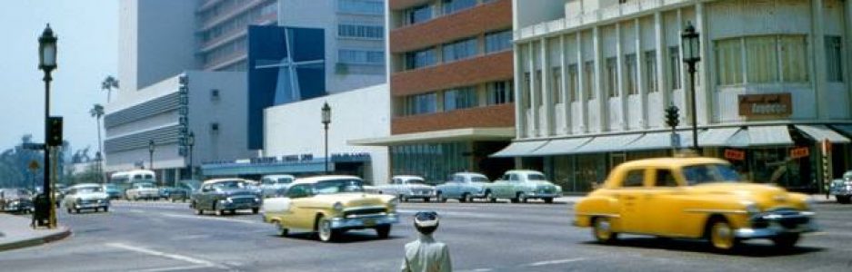

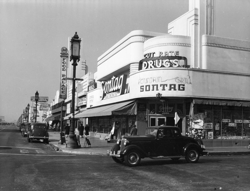
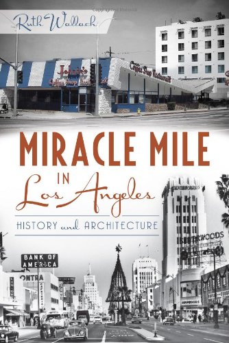
 [click on image to view]
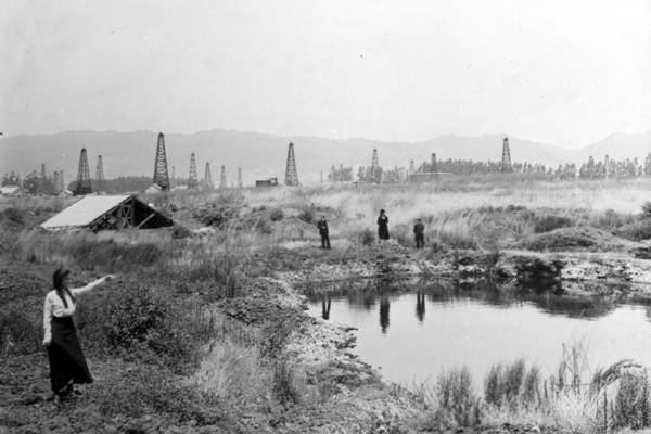
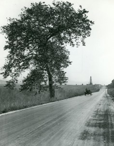
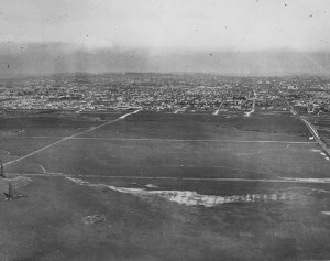
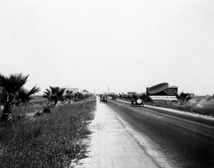
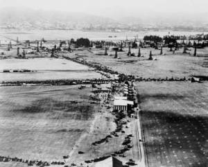

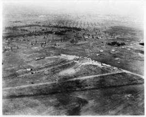
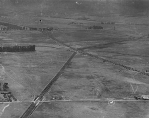
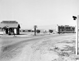
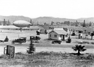
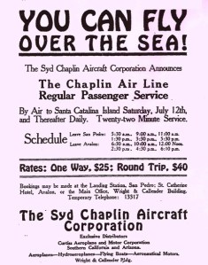
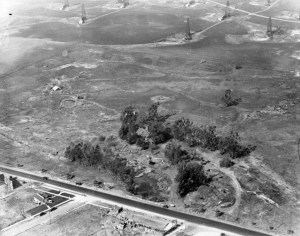
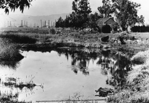
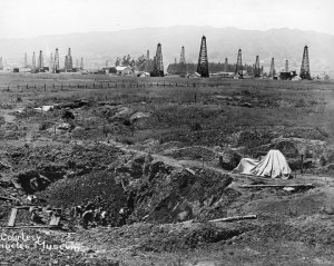


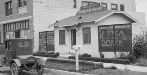
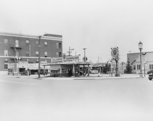
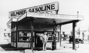


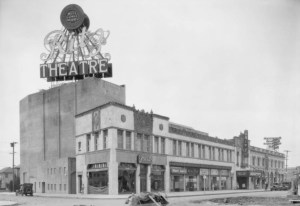
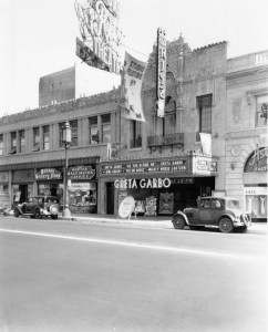
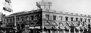
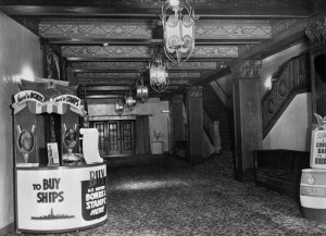

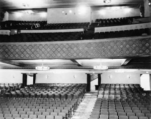
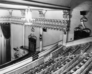

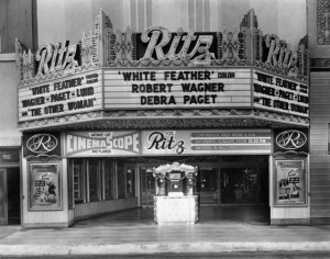


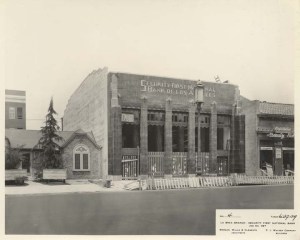
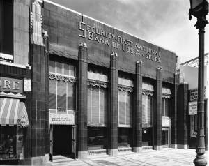
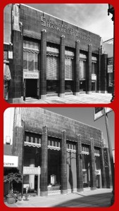
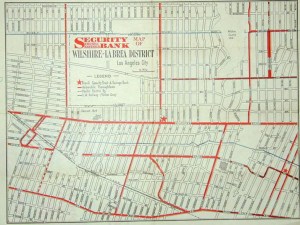
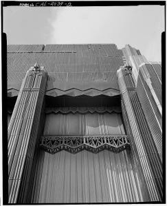
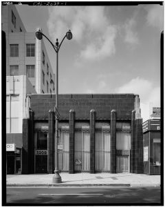

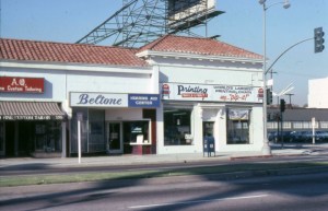

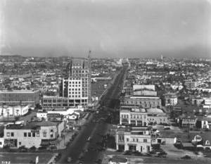

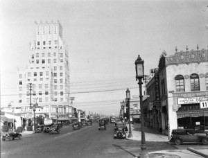
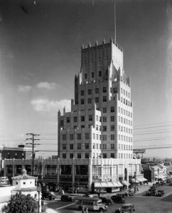
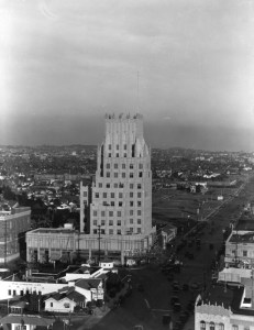

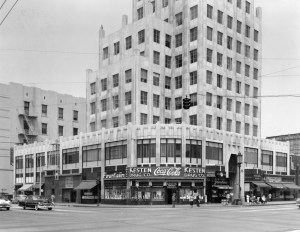
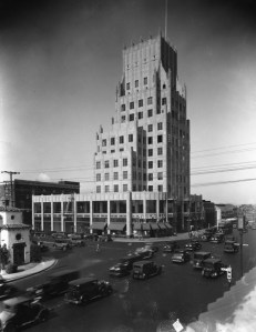
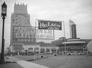
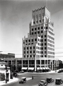
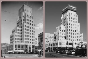
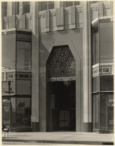
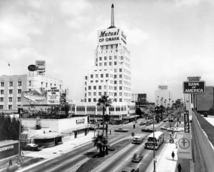
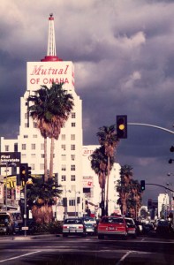
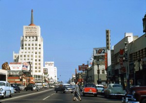
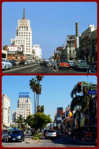
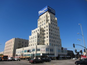
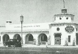
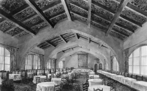
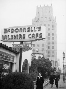
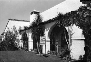
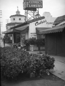


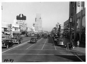

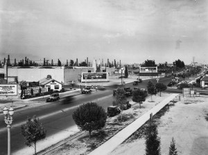


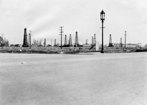


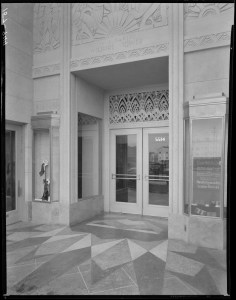
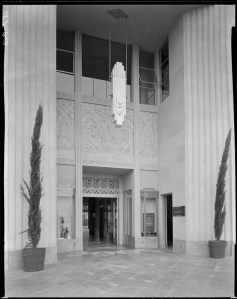
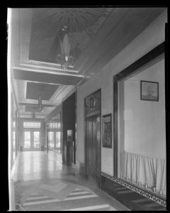
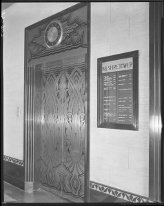
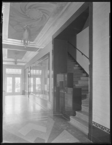
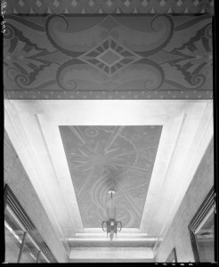
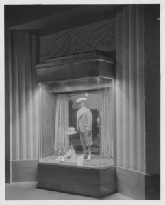
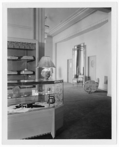

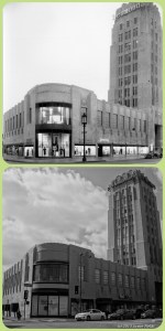


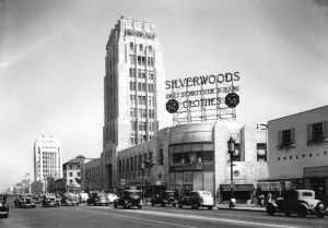

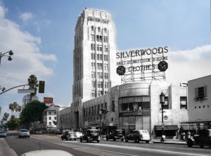

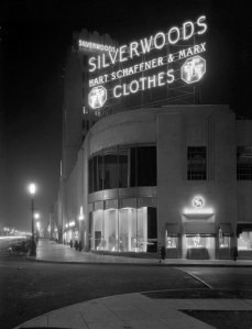
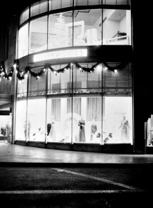

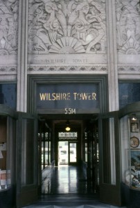
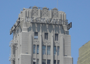
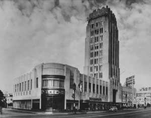
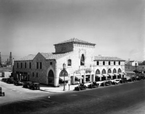
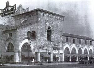

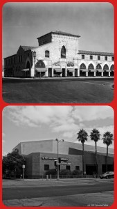

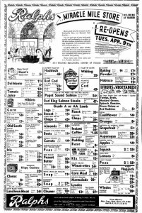


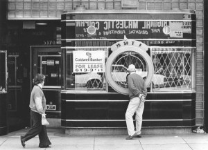

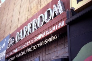


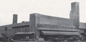
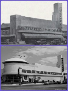
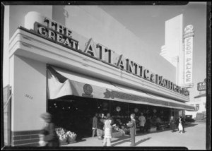
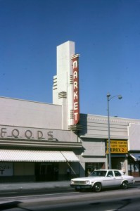
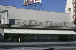
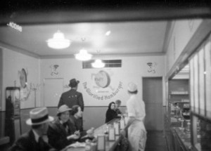
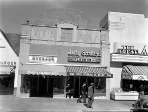
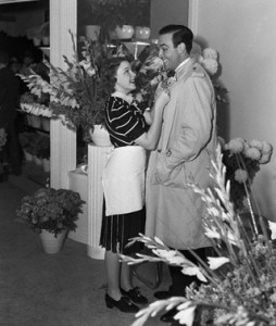


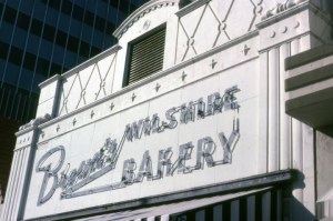
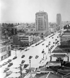
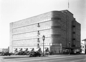
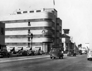

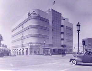
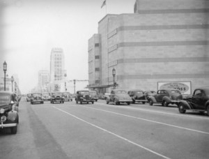
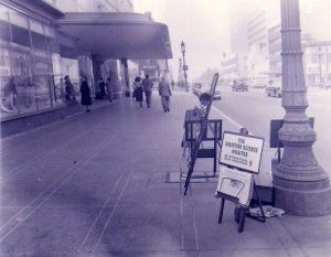


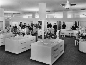
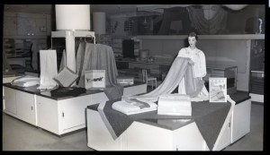
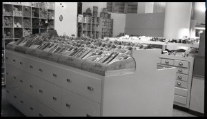
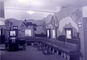

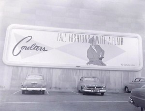

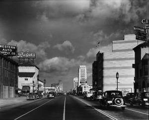

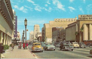

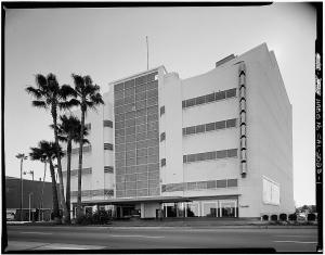
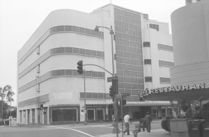
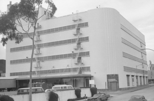
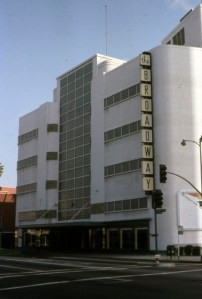
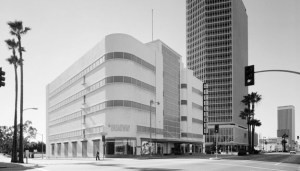
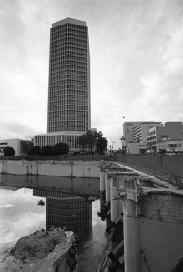

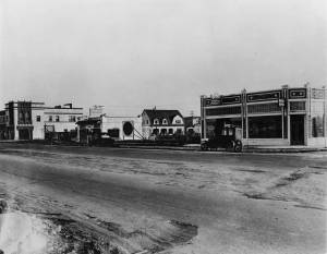

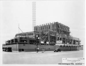
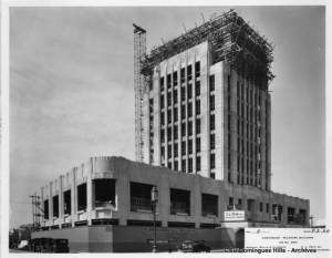
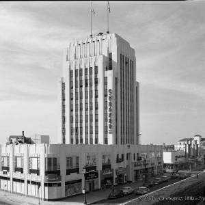

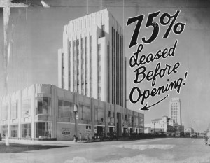
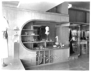
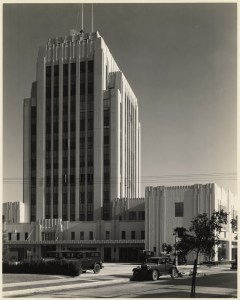

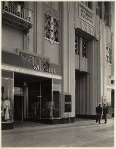
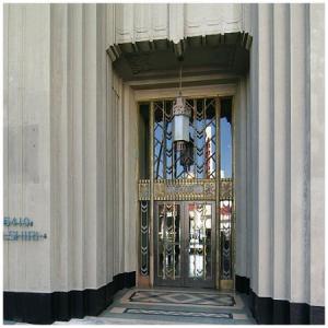
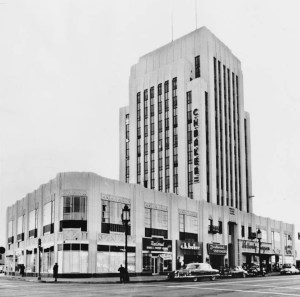


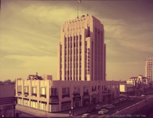
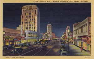
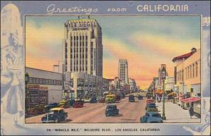
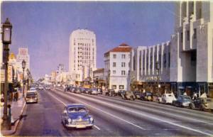
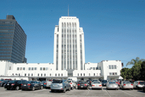
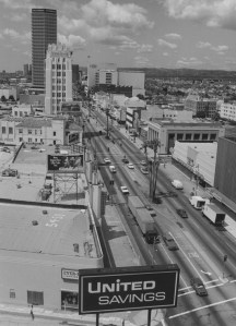
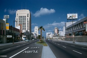
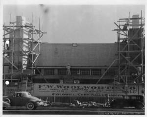
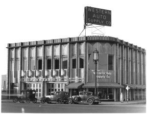

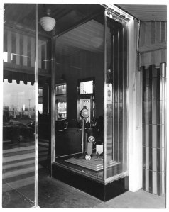

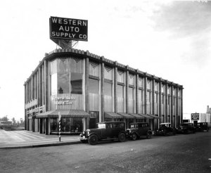


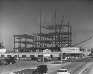
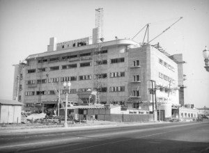
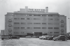
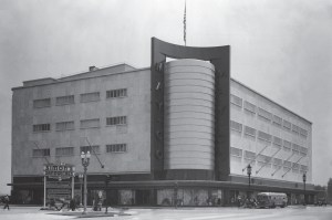
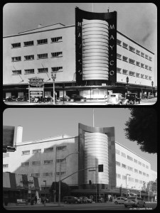
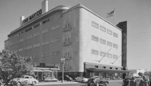

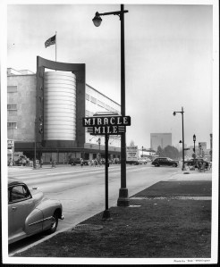
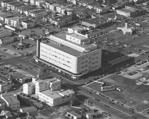
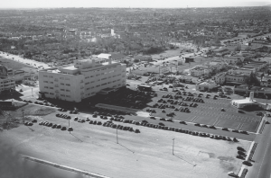
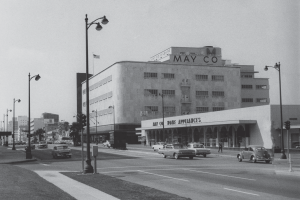

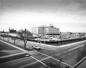
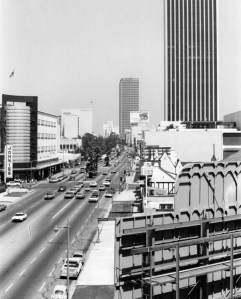

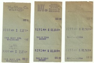
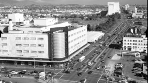
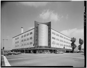

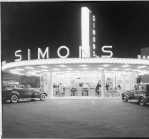


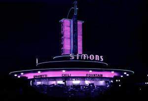

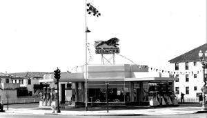
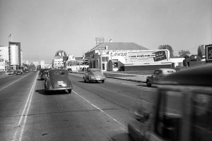

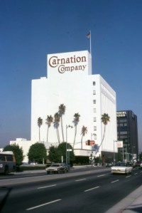
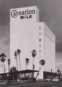
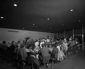


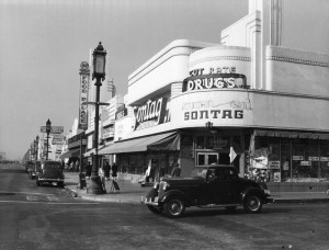
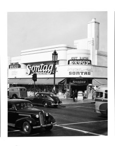
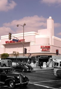
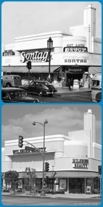
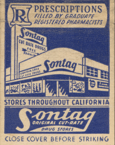

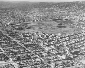
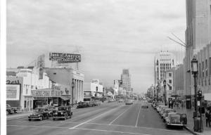

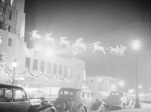
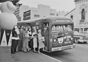

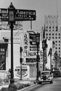
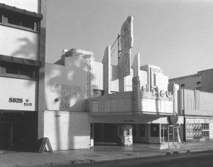
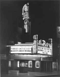

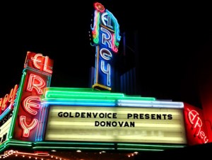
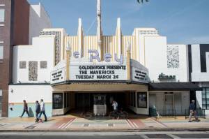
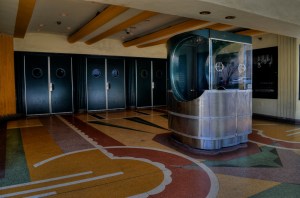
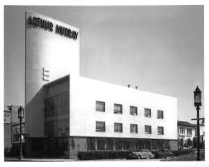

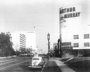
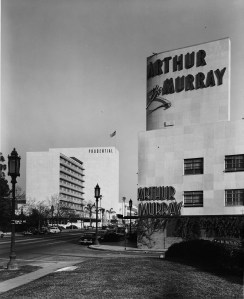


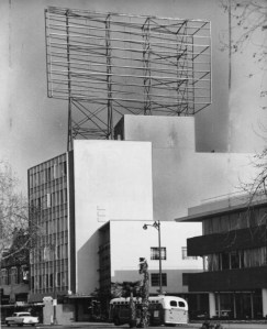
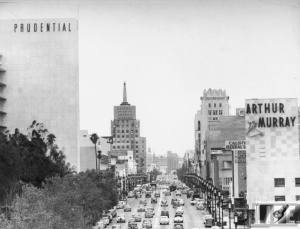
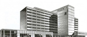
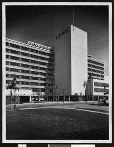
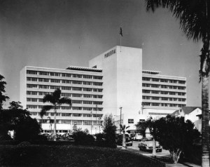


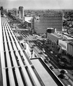
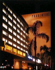
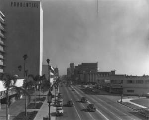

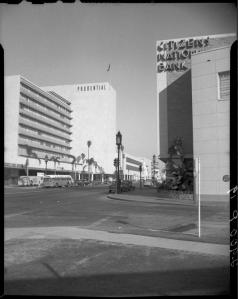


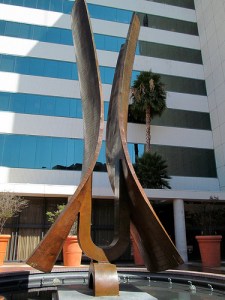


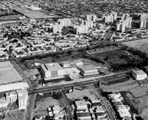
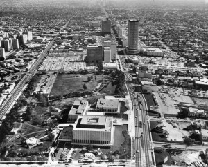
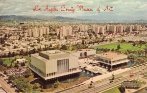
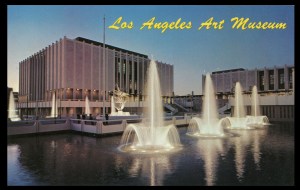
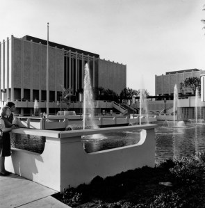
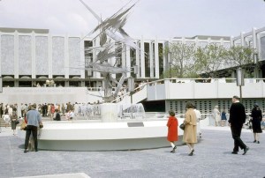
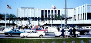
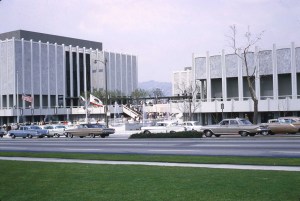

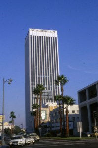
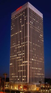
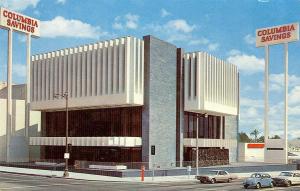
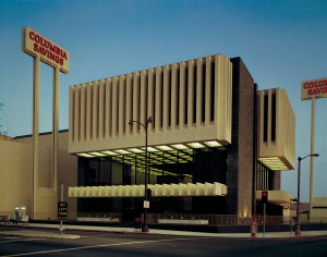
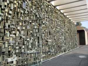


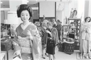
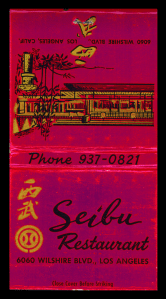
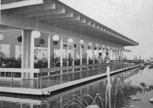
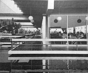
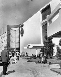


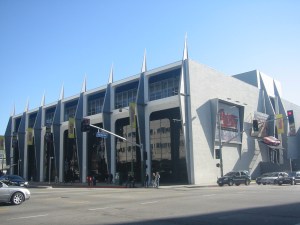


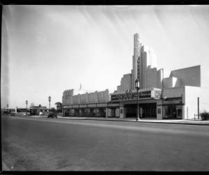
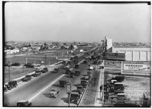

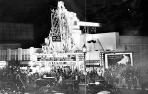
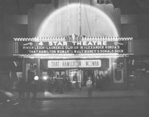
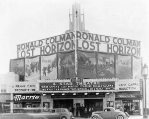

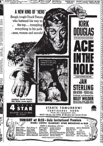


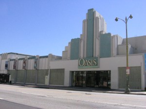
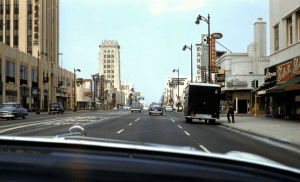


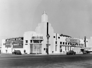
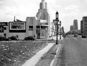
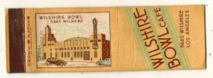
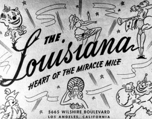
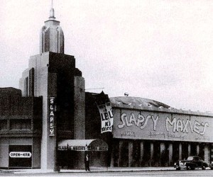
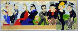
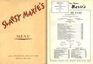
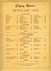
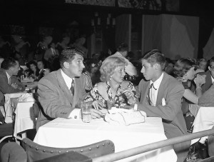
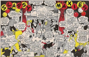


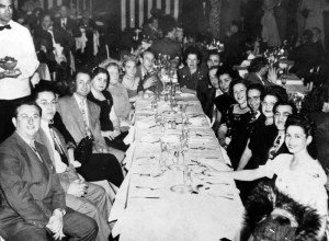
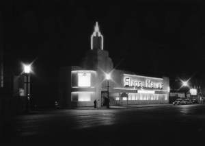
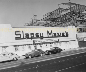
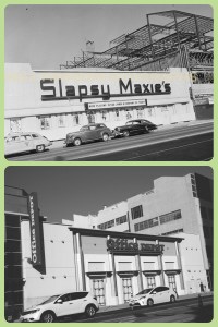


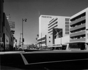

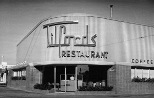
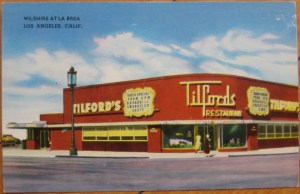


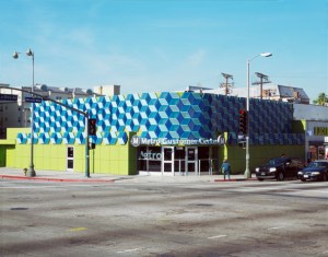


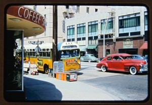
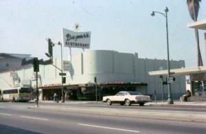
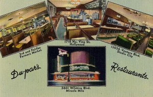

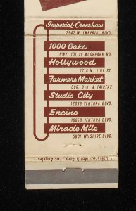
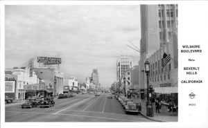
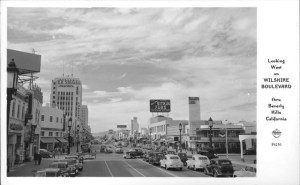
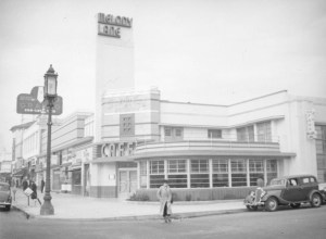
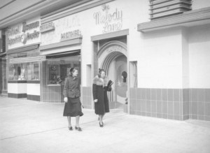
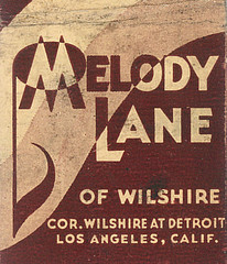
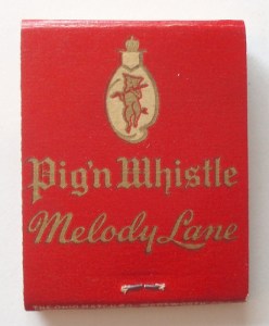


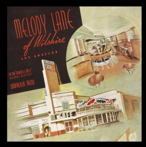
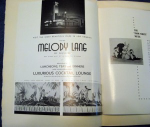
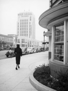
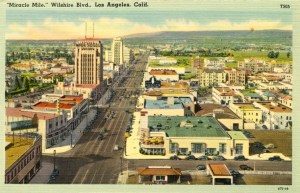


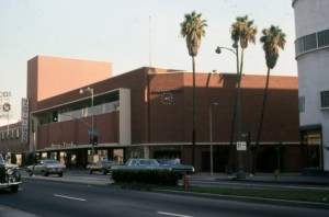

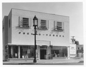

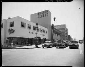
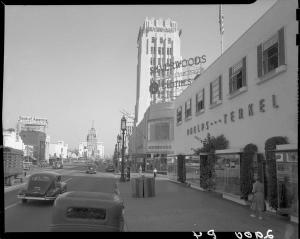
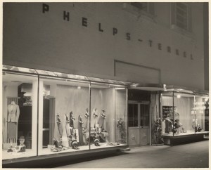
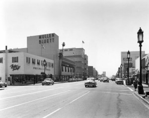
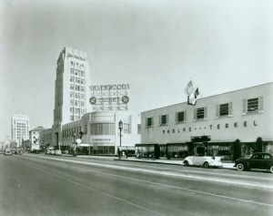
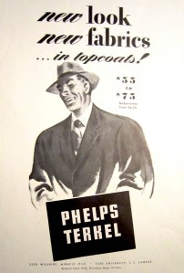
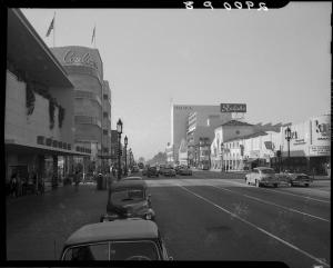
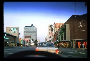
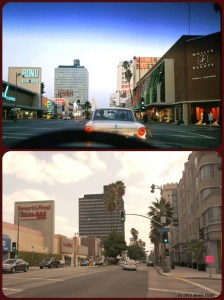
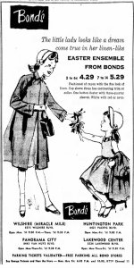


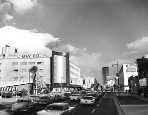


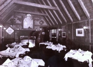

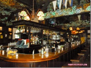
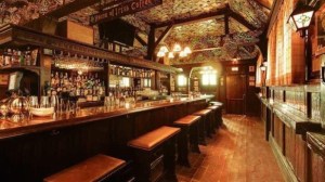
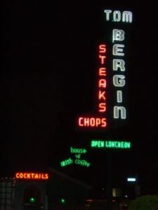

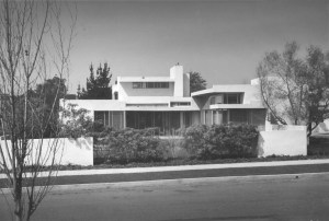
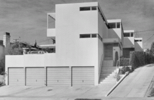
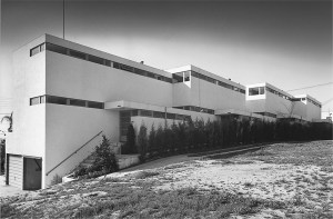

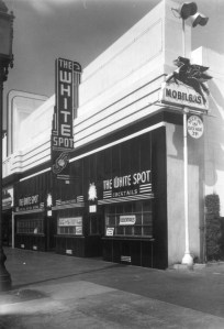
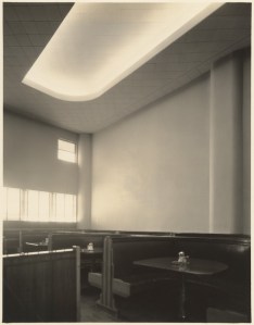

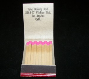
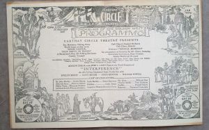
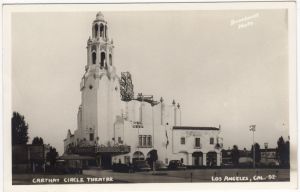
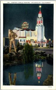
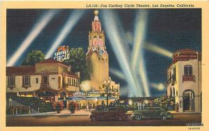


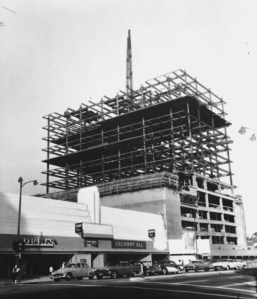
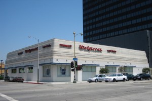
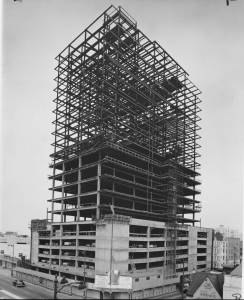


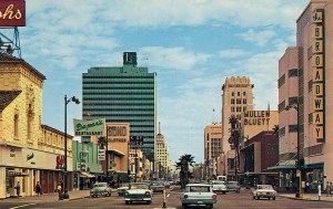


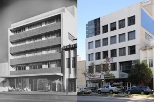
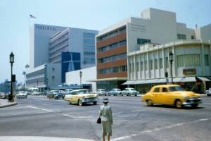
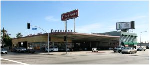
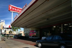
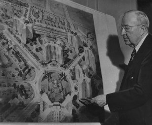
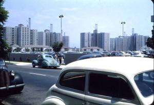

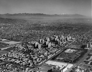
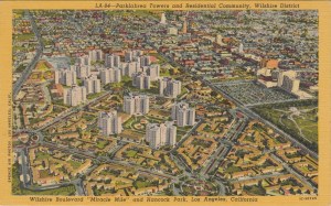
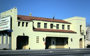
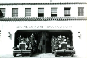
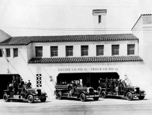


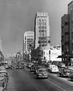
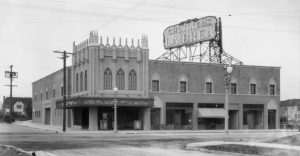
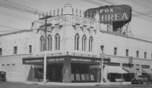


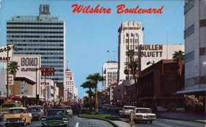


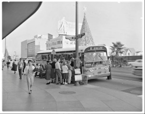


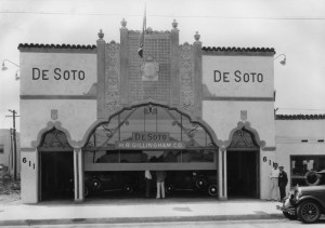
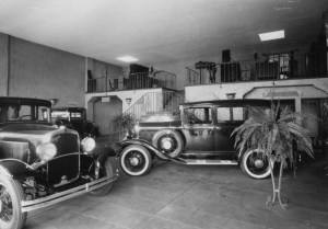
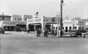

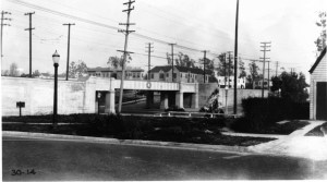
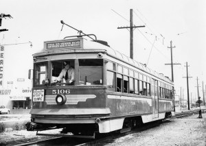
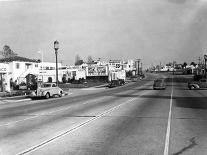
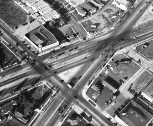

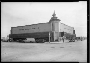

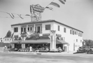
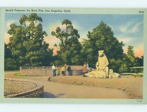


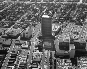


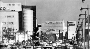
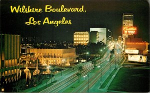

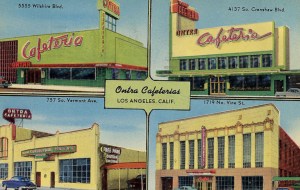


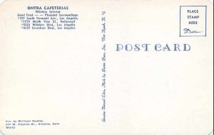

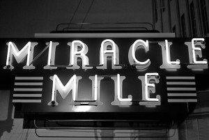


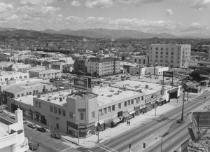
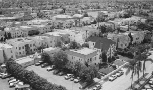
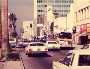
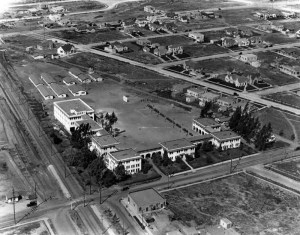
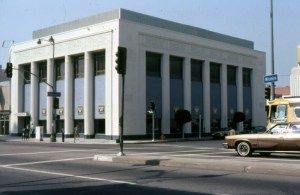
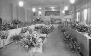
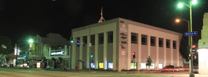
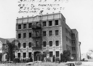
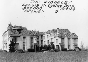
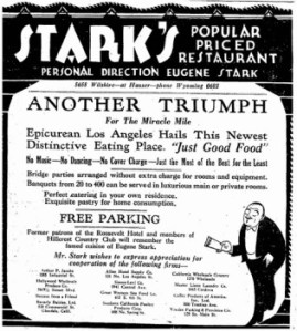
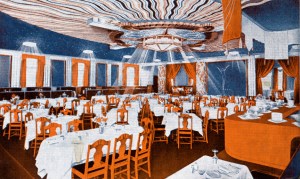

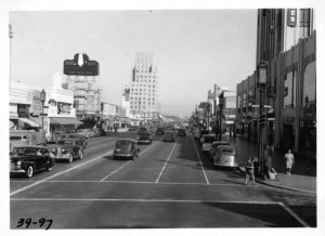
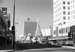
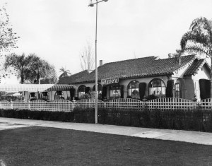

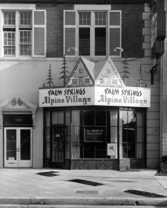


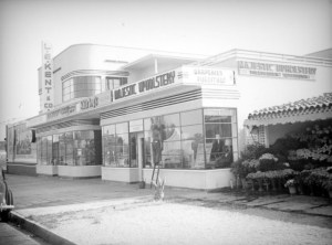

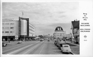
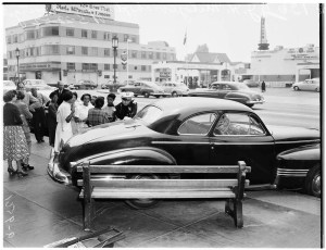

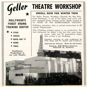

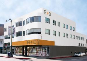


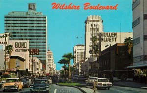


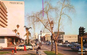
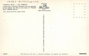
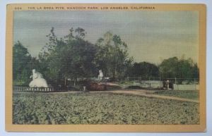

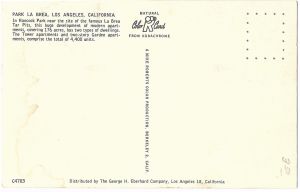
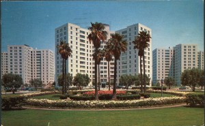


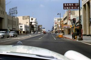
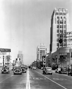
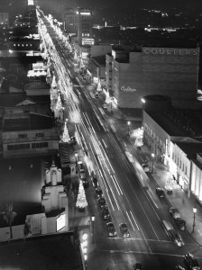
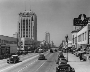
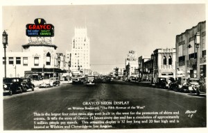


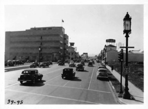
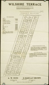


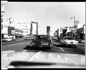


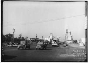


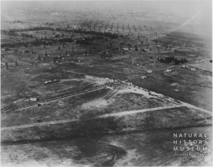
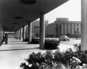

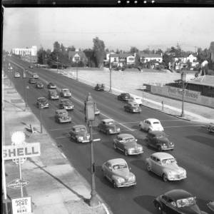


Great collection. Thank you for helping fill in my memories.
Lovely memories. Cant think of the n ame of a restaurant near Wilshire & Hobart in the 40 s that looked and seemed like the Fox & Hounds in Santa Monica that had red leather booths etc. Do you remember it?.
I worked at Prudential Insurance Company from 1976 to 1982. My favorite places to eat lunch were Shane’s Bakery, The Egg in the Eye, Dupar’s, and one restaurant no one remembers: The Green House. The best halibut, salmon and London broil was served at the Green House. I bought several works of art at the gallery below The Egg in the Eye. I also shopped at the Broadway across the street. I have fond memories of the Miracle Mile.
Correction:Coulter’s dept store did not become the Broadway dept store in the 70s as stated, it became the Broadwayin the 60s. I grew up on Sycamore and Wiltshire, in the 50s and 60s.
Does anyone have pictures of when they had live reindeer in a glass enclosure on Wilshire & Highland in the 60’s & early 70’s? I used to eat at Bob’s Big Boy & stare up at the reindeers. Only my sister remembers this. When I ask anyone else they think I’m crazy. I know I didn’t dream it. I can still see the condensation in that glass enclosure from the reindeer’s breath as it slowly spun around. Would love to see photos
There was a bar called Lane’s on Wilshire Blvd, in the Miracle Mile.. I use to frequent there in the, 80’s-90’s. When did it close?